The storm system that has impacted much of the nation from the Plains states to the Southeast over the past few days will move into the Northeast today.
Aside from the low pressure system impacting the East Coast, much of the nation is quiet to start the week. Image provided by NOAA.
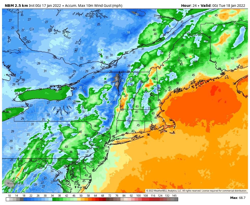
Low pressure will move up the Appalachians today and across New England, bringing some heavy rain and strong winds to the I-95 corridor from Philadelphia City to Boston, with heavy snow from the eastern Great Lakes into parts of northern New England. Rainfall totals of 1-2 inches are expected from the Mid-Atlantic states into southern New England this morning and early afternoon. The rain will be accompanied by strong winds. Sustained winds of 20-30 mph are likely across a large swath of the region, with gusts of 50-60 mph expected, especially near the shoreline. With tides at astronomical highs, the onshore winds will help to produce some minor to perhaps moderate coastal flooding, especially from Long Island into eastern New England.
Strong winds are likely across much of the Northeast today. Image provided by WeatherBell.
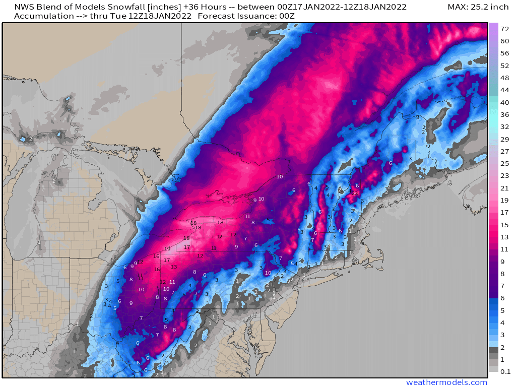
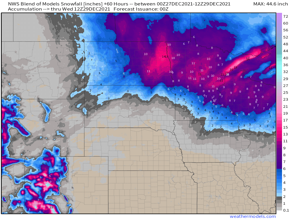
North and west of the track of the low pressure system, heavy snow is likely, especially across the eastern Great Lakes. Snowfall totals of 12-18 inches and locally heavier are expected from northeastern Ohio into northwestern Pennsylvania and western New York. This includes the Cleveland and Buffalo metro areas. Farther east, snow is likely across interior parts of New England, with some places picking up 4-8 inches of snow before a change to sleet, freezing rain and possibly plain rain occurs.
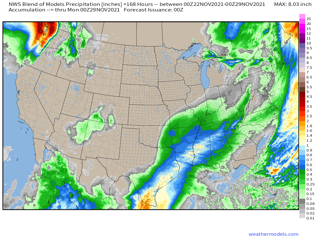
Heavy snow is likely north and west of the storm system today. Image provided by Weathermodels.com
Much of the remainder of the country will remain quiet this week, though another surge of arctic air will impact a large swath of the nation during the latter half of the week. The arctic air will drop into the Northern Plains by Wednesday, where temperatures will be 20 to 40 degrees below normal. As it spreads across the remainder of the eastern half of the nation for Thursday and Friday it will modify a bit, but temperatures will still be 15 to 25 degrees below normal across a wide area.
Another surge of arctic air is expected across much of the nation for the middle to latter half of the week. Loop provided by Pivotal Weather.
A much more tranquil weather pattern is expected across the nation over the next several days.
High pressure dominates much of the nation to start the week, Image provided by NOAA.
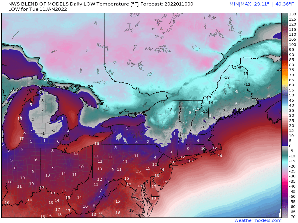
Arctic air will move out of the Northern Plains and into the Great Lakes today, then into the Northeast on Tuesday. Temperatures will be 20 to 30 degrees below normal, with a few record low temperatures possible. Subzero low temperatures are likely in much of the Upper Midwest this morning, and across northern parts of New York and New England both Tuesday and Wednesday mornings. High temperatures across the Northeast on Tuesday will only be in the single numbers in places such as Albany, NY and Worcester, MA, with teens likely closer to the coast including Boston and New York City. Temperatures should quickly moderate on Wednesday as high pressure slides offshore.
Tuesday morning will be quite chilly across the Northeast. Image provided by Weathermodels.com
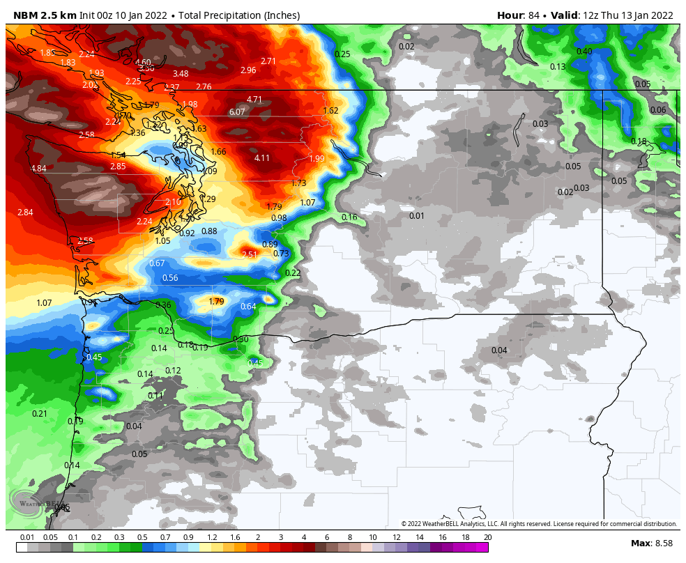
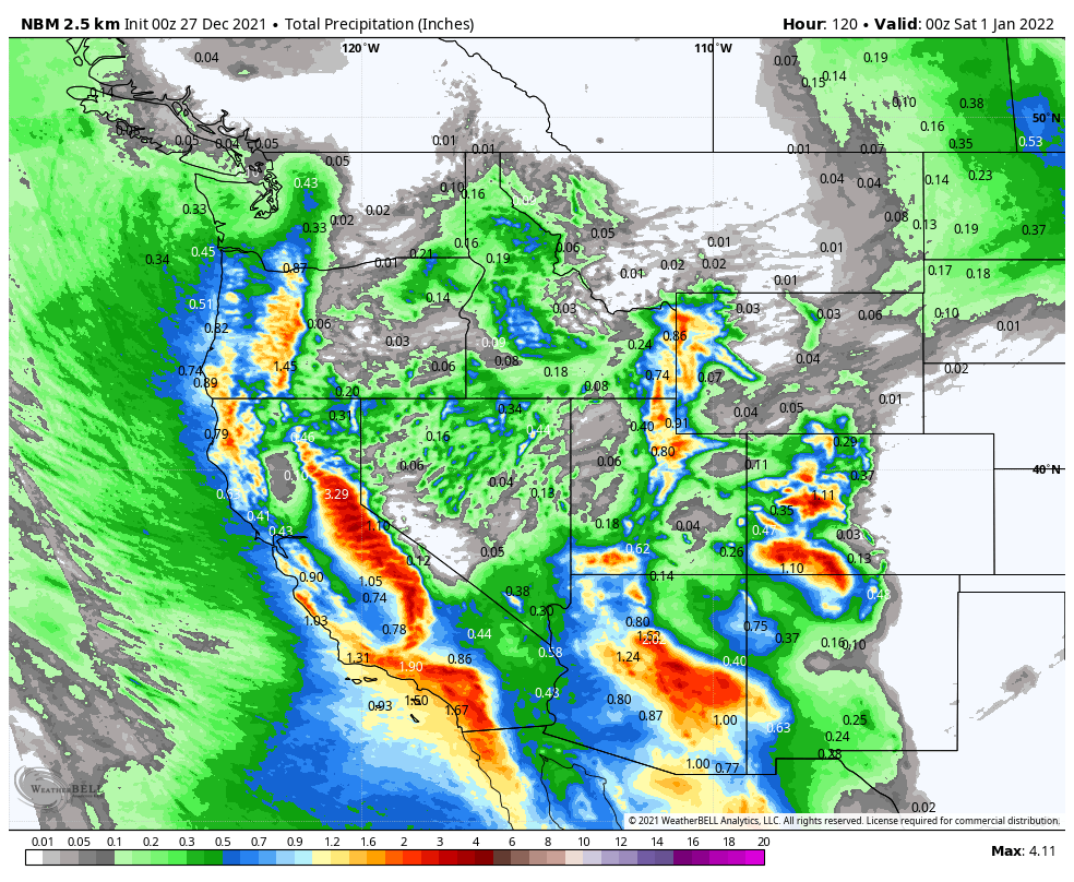
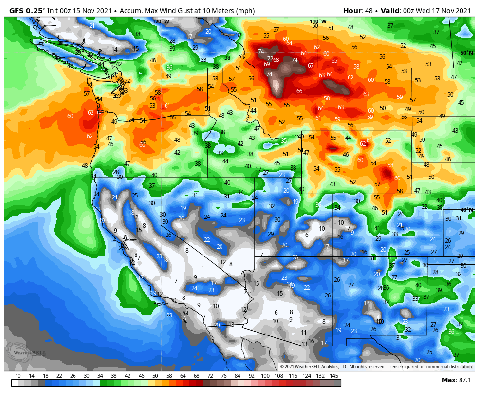
A low pressure system will move into the Pacific Northwest for Tuesday into Wednesday. Heavy rain is likely in parts of British Columbia, Washington, and northwestern Oregon. Rainfall totals of 3 to 5 inches are expected with some heavier totals possible. This will likely lead to flooding in parts of the region. Across the higher elevations of the Cascades, snowfall totals of 1-3 feet are possible.
Heavy rain is likely in parts of the Pacific Northwest over the next few days. Image provided by WeatherBell.
There is one other item we’re keeping an eye on this week. Many of the forecast models are showing the potential for a powerful storm to develop off the East Coast late in the week or next weekend. While the models have not performed all that well beyond 2 or 3 days, the fact that they are all showing something similar increases confidence a little. However, they don’t agree on the rest of the details, including, where the system will develop, how far offshore it will be (if at all), where it will track, how strong it will be, and what, if any, impacts it will have on land areas. We’ll monitor this as the week goes on.
The first snowstorm of the season is expected across the Mid-Atlantic States and stormy weather will continue across the Northwest this week.
A frontal system is draped across the East Coast while another system moves into the Northwest. Image provided by NOAA.
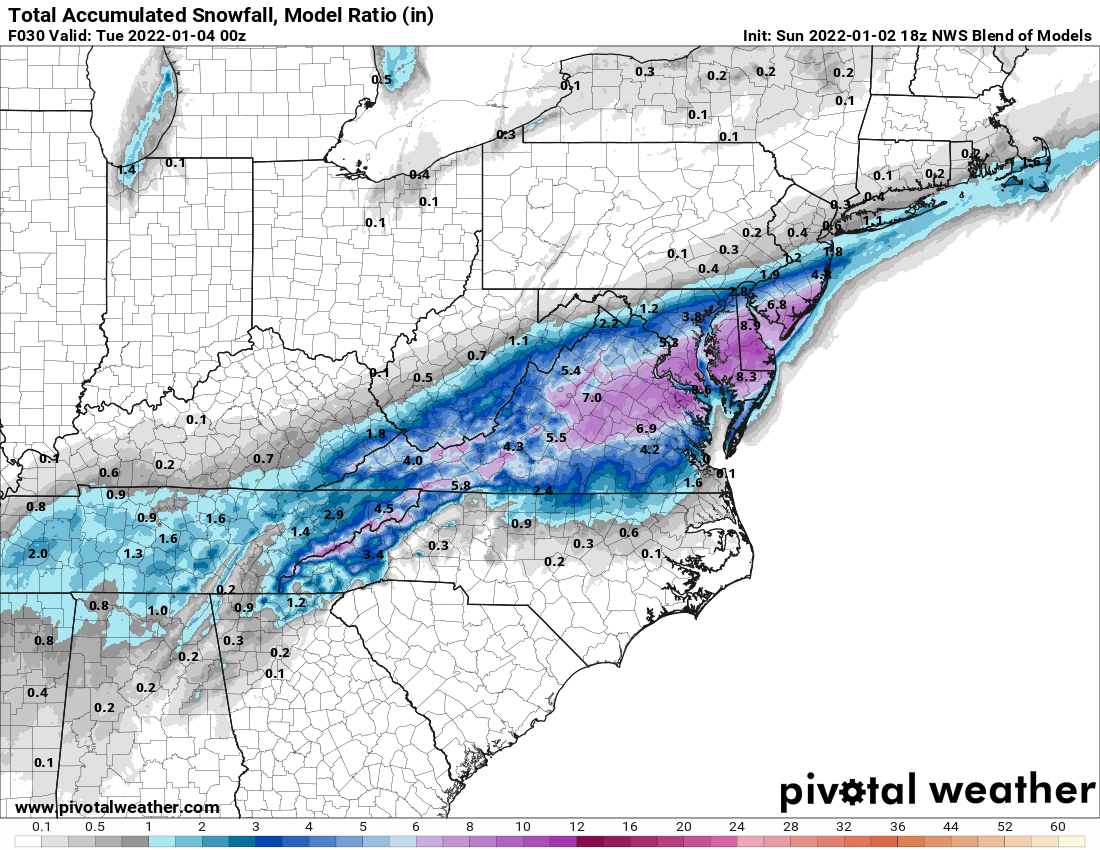
A strong cold front crossed the Northeast and Mid-Atlantic on Sunday, bringing an end to the mild weather the region had been experiencing. An area of low pressure will ride along the front today, bringing the first measurable snow of the season to parts of the Mid-Atlantic states, with some moderate to heavy snow in parts of the region. Snow will have a significant impact on the morning commute for Washington and Baltimore, and possibly Philadelphia and Richmond as well. The system will be moving along quickly, with snow ending during the afternoon, but a general 5-10 inches is expected from the central Appalachians to the Mid-Atlantic coast, with some heavier amounts possible. The system will also produce some heavy rain from the Tidewater of Virginia into the Carolinas, with a few strong thunderstorms possible as well.
The first snowstorm of the winter will impact the Mid-Atlantic states today. Image provided by Pivotal Weather.
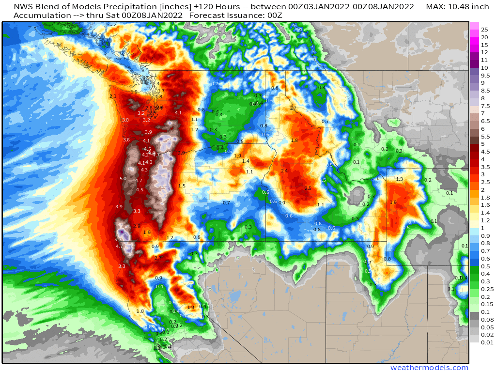
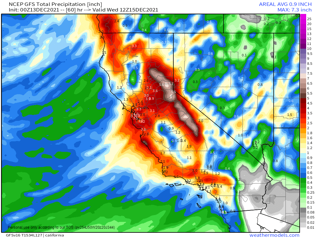
Out West, a stormy pattern will bring a series of low pressure areas into the West Coast over the next several days. Heavy rain is likely along the coast of Washington and Oregon, with rain also spreading southward into northern and perhaps central California. Rainfall totals of 1 to 4 inches and heavier will likely lead to flooding in some areas. Inland, heavy snow is likely across the higher elevations of the Cascades with several feet of snow likely. Snow will also spread into the Sierra Nevada, but the bulk of the snow will stay to the north.
Heavy rain is expected west of the mountains in the Pacific Northwest this week. Image provided by Weathermodels.com
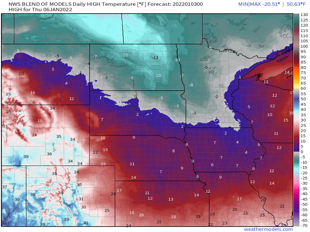
In between, a storm system will bring some snow into parts of the Northern Plains on Tuesday. Amounts shouldn’t be exceptionally heavy, but behind the system, another surge of arctic air is expected across parts of the Northern and Central Plains and the Upper Midwest. While temperatures won’t be anywhere near as cold as they have been over the past several days, temperatures will be 20 to 40 degrees below normal, with many locations likely staying below zero, even during the daytime, during Wednesday and Thursday.
Thursday looks like the coldest day for the next surge of arctic air. Image provided by Weathermodels.com
The other item we’ll be watching this week is the potential for another snowstorm in parts of the Mid-Atlantic states and the Northeast toward the end of the week. There is considerable disagreement among the forecast models in regards to the evolution of this system and what impacts, if any, it will have of the region, but it has the potential to bring snow to the I-95 corridor from Washington to Boston Thursday into Friday.
A rather active week is expected across the nation, with heavy rain and snow in the West and the Rockies, record heat and potentially severe weather in the South, and heavy snow and bitterly cold temperatures for the Northern Plains.
A frontal system extended from coast to coast separates unseasonably warm air to the south from colder air to the north. Image provided by NOAA.
Low pressure will move across the Northern Plains and into southern Canada today, with heavy snow across the Dakotas and into Minnesota as well as parts of Manitoba and Ontario. Winter Storm Warnings are in effect on the US side of the border, with Snowfall Warnings on the Canadian side. Snowfall won’t be exceptionally heavy, but many locations will pick up 6-12 inches. gusts of 35-45 mph are possible, which may result in near-blizzard conditions at times. Snow should wind down tonight, but another system passing south of the region on Tuesday may bring more snow into the region.
Moderate to heavy snow is likely over the next few days in the Dakotas and parts of the Upper Midwest. Image provided by Weathermodels.com
Later in the week, bitterly cold air will drop southward from Canada into parts of the Northern Plains and Northern Rockies, as well as the interior Northwest. Temperatures will be 15 to 25 degrees below normal across the interior Northwest, and as much as 20 to 40 degrees below normal in parts of Montana, the Dakotas, and northern Minnesota. Daytime highs will likely stay below zero for several days near the Canadian border, with low temperatures as low as 20 to 30 degrees below zero in parts of Montana and North Dakota.
The GFS shows the clash between bitterly cold air to the north and unseasonably warm air to the south right through the week. Loop provided by Pivotal Weather.
While bitterly cold air settles into the North, unseasonably warm weather is expected across the South. High temperatures will reach the 70s and 80s from Texas to the Southeast over the next several days, which is 20 to 30 degrees above normal. Dozens of record highs are likely to be set across the region.
Low pressure will move into the Mississippi Valley by mid-week. With a warm, humid airmass in place, showers and thunderstorms are likely ahead of the system. Conditions could be ripe for some severe weather Wednesday into early Thursday, especially in parts of Louisiana, Alabama, and Mississippi.
Severe weather is possible across parts of the Lower Mississippi Valley and Deep South on Wednesday. Image provided by NOAA.
Meanwhile, out West, heavy rain and snow will continue across the region. With colder air in place, snow was observed right to the coastline in parts of Washington and Oregon on Sunday. The Seattle metropolitan area received 3-6 inches of snow, with 1-2 inches in the Portland area. As the low pressure area that produced the snow moves inland, more snow is likely, especially in the Cascades and Sierra Nevada, with rain into the lower elevations of California. Another system will follow right behind, with more heavy rain and mountain snow for the West Coast later this week. Rainfall totals of 1-3 inches and locally heavier will result in flooding in some areas, especially Southern California. Across the Sierra Nevada, snowfall totals of 3 to 6 feet are possible.
Heavy rain is expected across the West this week. Image provided by WeatherBell.
Right now, First Night festivities in New York City shouldn’t have any weather problems. In fact, it looks rather nice for revelers heading to Times Square to watch the ball drop. Right now, it looks like skies will be partly cloudy with temperatures around 40 degrees at midnight Friday night.
As we approach Christmas, a stormy pattern will continue across the West while another warmup is expected in the Plains.
Much of the US is quiet to start the week. Image provided by NOAA.
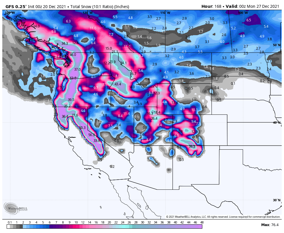
Rain and mountain snow will continue from the Northwest into the Northern Rockies today as low pressure moves across the region, but drier weather should settle in for Tuesday. After that, a series of low pressure areas will bring heavy rain and mountain snow to much of the West from Wednesday into the weekend. Rainfall totals of 2-4 inches and locally heavier are likely from British Columbia southward to southern California, which will likely lead to flooding in some areas by late in the week. The bigger story will be the snow in the mountains. The snowpack in the Sierra and Cascades is still below normal, but that is likely to change later this week. The potential exists for some places to receive as much as 5 to 10 FEET of snow over the next 7 days. This will result in travel problems crossing the mountains. By the end of the week, as colder air settles into the Northwest, snow is possible at the lower elevations, including the Seattle and Portland metropolitan areas.
Heavy snow is expected across the West later this week. Image provided by WeatherBell.
The other thing we’re watching is the return of warm weather to the Southern Plains and parts of the South and East later this week. By the middle of the week, temperatures will be 15 to 30 degrees above normal across the central and southern Plains. That warm will spread eastward, but will be modified a bit as it does so, with well above normal temperatures moving toward the East by the end of the week. A few records are possible across parts of the region. Another burst of warm air may move back into the Southern Plains and Texas next weekend.
Unseasonably warm weather returns to the Plains and the South this week. Loop provided by Pivotal Weather.
Meanwhile, bitterly cold air will build across western Canada this week. Temperatures could be as much as 25 to 50 degrees below normal in many areas later this week. Daytime highs of -30 to -40C are possible in parts of the Yukon, Northwest Territories and northern British Columbia. Some of that arctic air may spill southward into parts of Montana and the Dakotas for Christmas weekend.
Stormy weather will return to the West Coast over the next few days, and could spread into the Northern Plains later this week.
Low pressure is bringing unsettled weather to parts of the West. Image provided by NOAA.
A low pressure system will bring heavy rain, gusty winds, and mountain snow to much of the West over the next few days, with a second system following for Tuesday into Wednesday. It has been relatively dry across the region recently, so the rainfall is welcome, but amounts could be excessive in spots. Rainfall totals of 1-2 inches will be fairly widespread, but some locations, especially along the California coast, could see upwards of 3-5 inches of rain. Flood Watches are in effect for parts of the Golden State. The rain will be accompanied by strong winds, which will be widespread not only along the West Coast, but well inland into the Great Basin and parts of the Southwest. Wind gusts of 30-50 mph will be common, with Wind Advisories in effect for many locations. The storm will also produce heavy snowfall across the mountains of the West, especially the Sierra Nevada, where snowfall totals of 2-4 feet or more are expected.
Heavy rainfall is likely across much of the West over the next few days. Image provided by Weathermodels.com
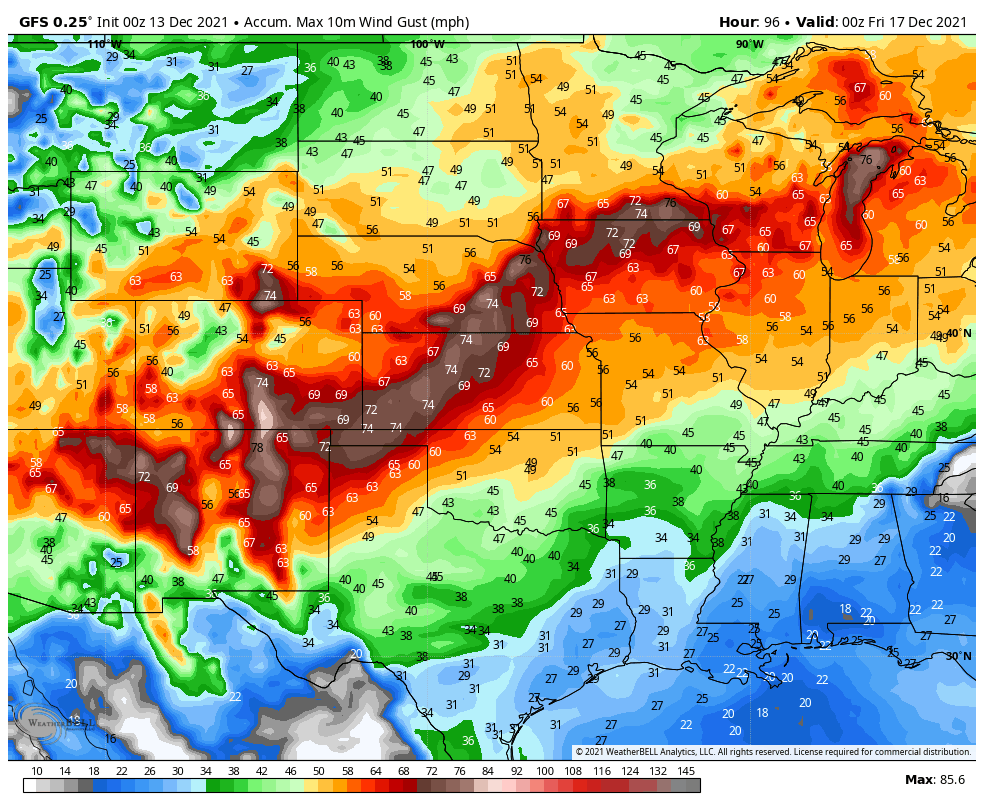
By mid-week, the storm will redevelop east of the Rockies, and head northeastward across the Plains States toward the Upper Midwest. It may produce some light to moderate snow from the Central and Northern Plains into the Upper Midwest, but the bigger story will be the strong winds it generates across the Plains States and into the Mississippi Valley. The potential exists for widespread wind gusts of 50-70 mph or stronger. In the Northern Plains, when you combine the winds with the snowfall, blizzard conditions are possible in parts of the Dakotas and Minnesota Wednesday into Thursday. The system may also generate more severe weather ahead of it from the Mississippi Valley into the Ohio and Tennessee Valleys later Wednesday into Thursday.
Strong winds are possible across much of the nation’s midsection Wednesday into Thursday. Image provided by WeatherBell.
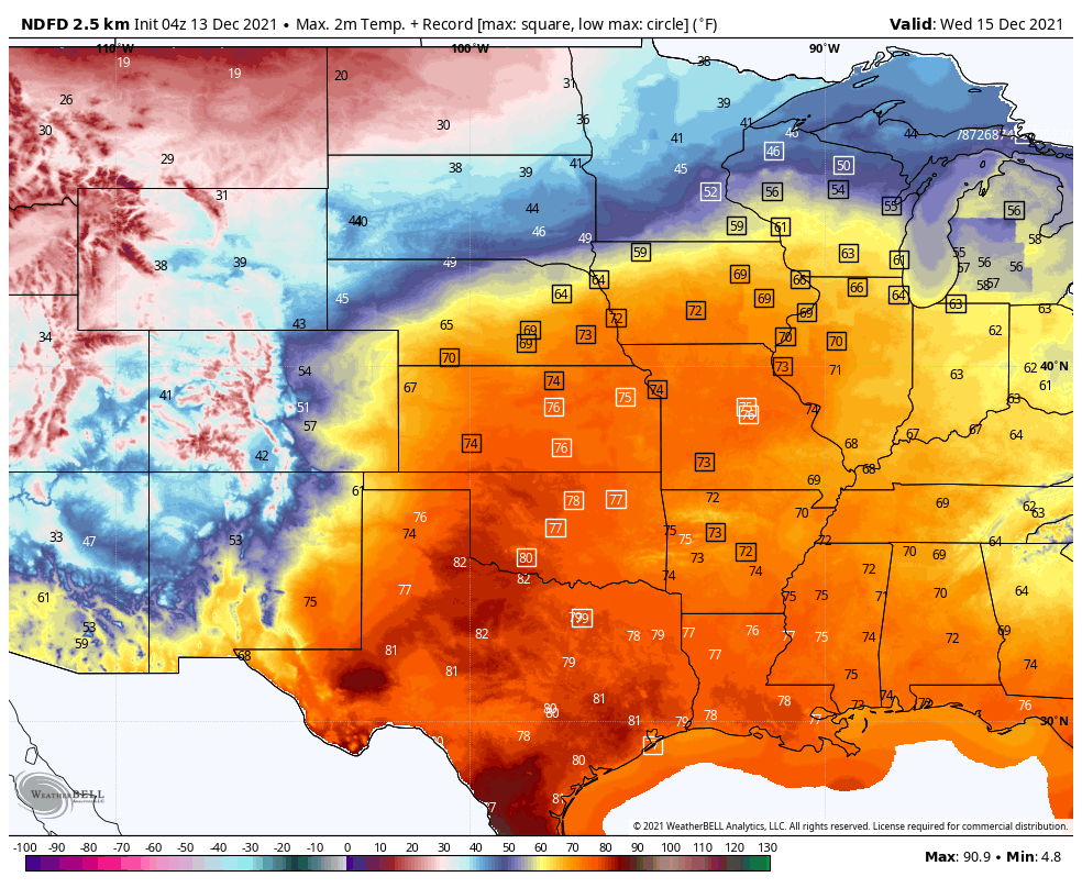
The other big story will be the temperatures on either side of this storm system. Unseasonably mild weather is already in place across much of the nation today, but that’s just a taste of what is coming. On Tuesday, temperatures will be 15-25 degrees above normal across most of the Plains States and the Mississippi Valley, with some records possible. Wednesday looks to be the warmest day in this region, with dozens of records expected. Temperatures will be well into the 60s and 70s, which is 15 to as much as 35-degrees above normal. The warm weather will shift into the eastern third of the nation for the latter half of the week, where temperatures will be 15-25 degrees above normal.
Dozens of record highs are likely across the Central US on Wednesday. Image provided by WeatherBell.
Behind the system, much cooler weather will settle into the West for Tuesday and Wednesday, with temperatures dropping to 8 to 15 degrees below normal. The cooler air will shift into the Northern Plains by Thursday, and across the rest of the Plains for the end of the week, with temperatures running as much as 10 to 20 degrees below normal.
The weather pattern is fairly active across the nation right now, and there are several areas we’re keeping an eye on.
The pattern has become very active over the past several days across the nation. Image provided by NOAA.
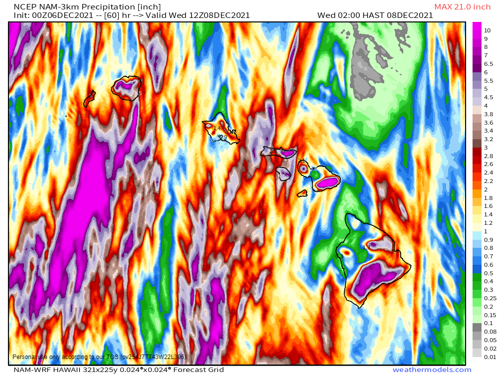
We’ll start off in the Pacific, where a low pressure system will bring a wide variety of impacts to the Hawaiian Islands today and tomorrow. Heavy rain will lead to widespread flooding across the islands, with strong winds also creating damage. Rainfall totals of 3-6 inches and locally heavier are expected through Wednesday. Flood Watches are in effect for much of the region. High Wind Warnings and Wind Advisories are also in effect, for sustained winds of 20-40 mph, with gusts of 50 to 60 mph possible. Along west-facing shorelines, waves of 8 to 12 feet will batter the beaches, where High Surf Advisories are in effect. If that wasn’t enough, across the higher summits of the Big Island, a Blizzard Warning remains in effect. Heavy snow will continue this morning with several more inches of accumulation possible. The snow will be accompanied by winds gusting as high as 80 mph, resulting in blizzard conditions.
Very heavy rain is likely across the Hawaiian Islands for the next few days. Image provided by weathermodels.com
Next, we’ll stay in the Pacific, but head northward to Alaska. A strong low pressure system is sitting just west of the the state early this morning, and it is having a significant impact on the region. Blizzard warnings are in effect for parts of western and southern Alaska. Heavy snow will be accompanied by winds gusting as high as 70 mph. The strong winds, combined with astronomically high tides, will result in flooding along the coast as well. Heavy snow is also likely for many locations, with up to 8-16 inches for many areas, and even more in some spots. Across the higher elevations, several feet of snow are expected. The only positive to this is that the brutally cold weather that much of the state experienced in November has been replaced by temperatures that are well above normal, though bitterly cold air will likely return behind this storm system.
A powerful storm system will impact Alaska over the next few days. Image provided by NOAA.
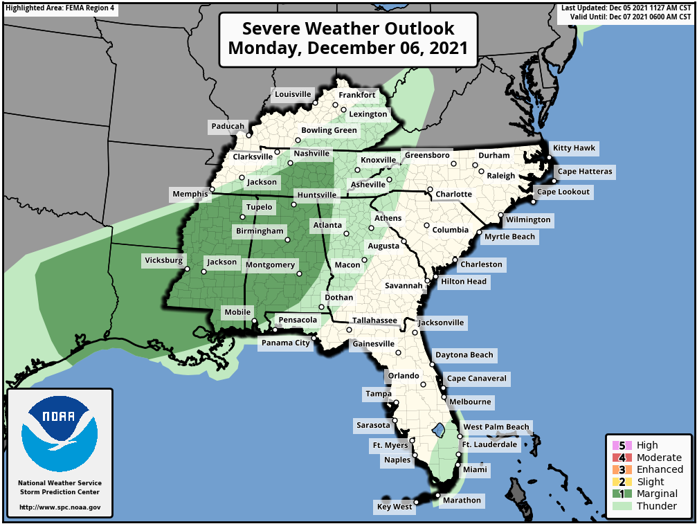
Across the Lower 48 States, the low pressure system moving into the Mississippi Valley this morning will garner the most attention today. It produced heavy snow in the Northern Plains and severe weather in the Mississippi Valley on Sunday. It will move into southern Canada today, dragging a strong cold front eastward. Ahead of the front, unseasonably mild air is expected across the East Coast, with temperatures topping 60 as far north as New England, and 70s into the Mid-Atlantic states. The warmth will be accompanied by some showers and gusty winds. Wind advisories are in effect for parts of the Northeast. Along the Gulf Coast and into the Lower Mississippi Valley, some strong to severe thunderstorms are possible ahead of the cold front. Some of the storms may produce strong winds, hail, heavy downpours, and possibly a few tornadoes.
Severe weather is possible in parts of the Lower Mississippi Valley today. Image provided by the Storm Prediction Center.
Another system will quickly follow for the Mid-Atlantic and Northeast on Wednesday. There’s quite a bit of uncertainty with the evolution of this second storm, but it has the potential to bring the first accumulating snow of the season to the I-95 corridor. While heavy snow seems unlikely at this point, some light to perhaps moderate accumulations are possible, which would result in travel issues for the heavily-populated region.
There is not a lot of agreement among the forecast models on what impacts the midweek storm will have and where they will be. Images provided by Pivotal Weather.
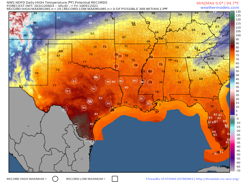
The other area we’re watching is the Southern Plains and Texas. After some record warmth over the past several days, cooler weather will settle in today and into Tuesday. However, another big warmup is expected later this week. Some record high temperatures are possible across the region on Thursday, but Friday looks to be the warmest day, with numerous records likely to be broken as highs soar well into the 70s and 80s, with 90s possible in southern Texas.
Numerous record high temperatures are in jeopardy by Friday as very warm air settles into the Southern Plains and Gulf Coast. Image provided by Weathermodels.com
On the flip side, very chilly air will settle into the Dakotas and Minnesota today in the wake of yesterday’s snowstorm. High temperatures will only reach the single numbers for parts of the region today, with some locations possibly staying below zero all day. Temperatures should start to moderate by tomorrow across the area.
Once again, a majority of the nation will be spared from major storminess during much of the upcoming week.
The week is starting off without any significant storm systems on the surface map. Image provided by NOAA.
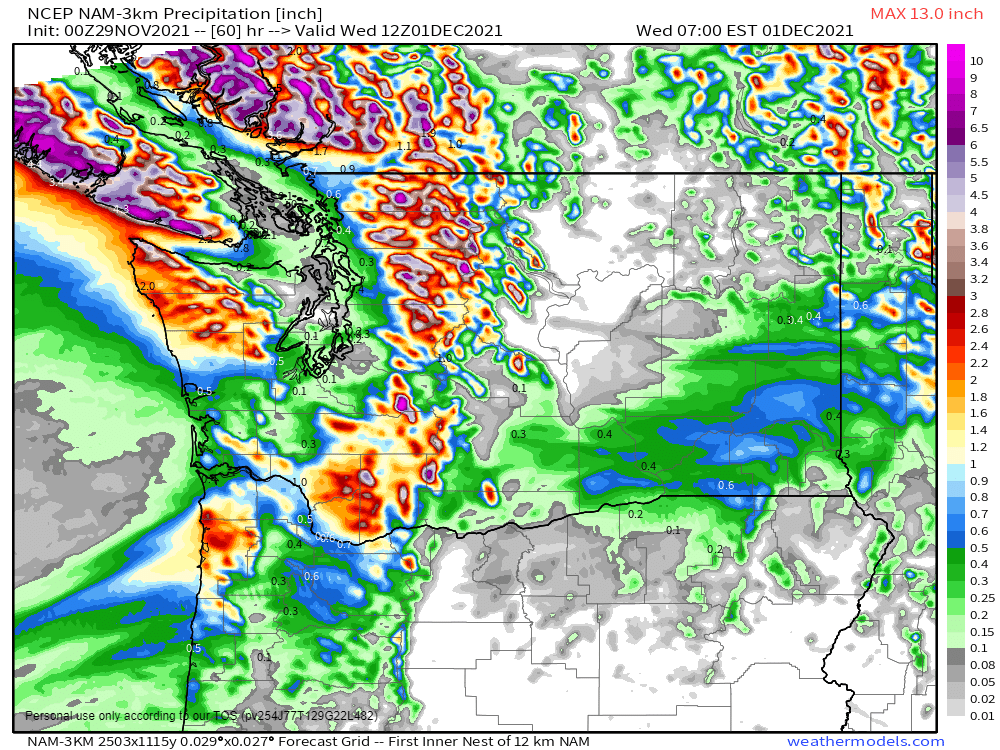
As is typically the case at this time of year, the Northwest will be the exception to the rule when it comes to quiet conditions. As one system pulls away from the region today, another one will move in from the Pacific later Tuesday into Wednesday with rain, some of it heavy, and higher elevation snow in parts of Washington and Oregon. While this rainfall won’t be anywhere near the magnitude of some recent storms, some locations, especially in the Olympic Peninsula, could see 1-3 inches of rain, which may lead to some flooding.
Some heavy rain is possible across parts of Washington State on Tuesday. Image provided by Weathermodels.com
The other main story this week will be unseasonably warm weather for a large portion of the nation, especially west of the Mississippi River, for the next several days. Much of this region will have temperatures that are 15 to 30 degrees above normal through at least Thursday or Friday. Dozens of record highs are likely to be set from the Plains states into the Rockies and the Pacific Northwest, especially Wednesday and Thursday. High temperatures could top 70 as far north as parts of South Dakota and Wyoming by Thursday.
Unseasonably warm weather is expected across much of the nation this week. Loop provided by Pivotal Weather.
A cold front will drop southward out of Canada toward the end of the week, bringing an end to the warm spell. A wave of low pressure riding along the front may produce some light to perhaps moderate snow from the Northern Plains into the Great Lakes next weekend.
The weather can often have an adverse impact on Thanksgiving travel, but that doesn’t look to be the case this year.
The cold front extended from the Great Lakes to Texas will be the focus of attention today. Image provided by NOAA.
Fairly quiet weather is expected across much of the nation during the upcoming week. A cold front will move off the East Coast today with some showers ahead of it otherwise, most of the nation will be dry into Wednesday. By Wednesday night and Thanksgiving, another cold front will be moving across Great Lakes and Ohio and Mississippi Valleys, producing some showers, with snow showers in parts of Great Lakes, but none of the precipitation looks heavy except possibly from Texas into the Lower Mississippi Valley, so it shouldn’t impact travel too much. As that front reaches the East Coast on Friday it will produce some showers, with lake-effect snow showers behind it, downwind of the Great Lakes. Our next system will also be bringing some light rain and mountain snow into parts of the Northwest.
Except for the Northwest and Lower Mississippi Valley, much of the nation won’t see much precipitation this week. Image provided by Weathermodels.com
Temperatures will be riding a rollercoaster this week with chilly air in the East to start the week, with very mild air across the Plains and Rockies. While the East Coast will remain chilly into Wednesday, that warm air over the Plains will spread into the Mississippi and Ohio Valleys as well as the Southern Plains by mid-week, while much cooler air returns to the West and especially into the Northern Plains. By the end of the week, the East will turn much milder for a day or two while the cold air settles into the Great Lakes and Mississippi Valley, before reaching the East Coast next weekend. Meanwhile, another significant warmup is expected in parts of the Plains and the Rockies as well as much of the West.
Temperatures will alternate between quite mild and quite chilly over much of the nation this week. Loop provided by Pivotal Weather.
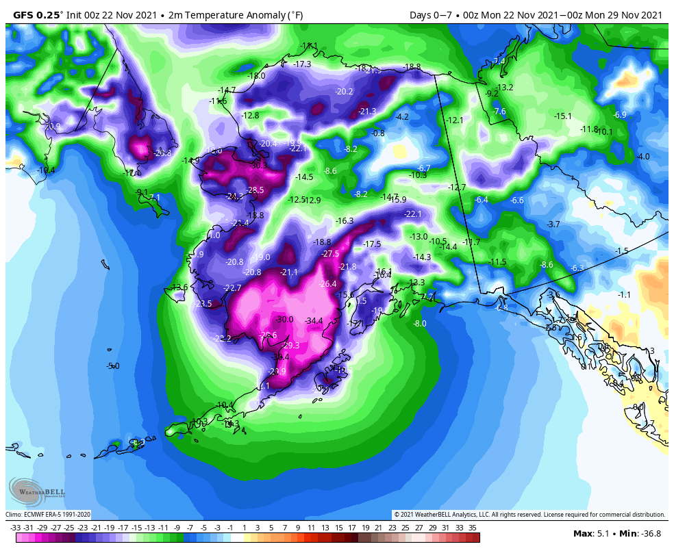
While temperatures have been variable across the Lower 48, very cold air has settled into Alaska over the last week or two, and it will remain in place for the next week at least. Temperatures over the next 7 days will average 15-35 degrees below normal across much of the state. Parts of northern Alaska could see low temperatures dropping to -40F or colder over the next several nights.
Bitterly cold air will remain in place across Alaska for most of the upcoming week. Image provided by WeatherBell.
A quiet weather pattern is expected for a large portion of the nation for much of the upcoming week.
There are several frontal systems on the surface map to start the week, but no big storms. Image provided by NOAA.
A low pressure system moving in from the Pacific will bring some heavy rain, higher elevation snow, and strong winds to the Northwest and Northern Rockies over the next few days. Flood Watches and Warnings are in effect for parts of western Washington. Rainfall totals of 1-3 inches and locally heavier are expected in parts of Washington, Oregon, and northern California. Across the higher elevations of the Cascades, snowfall totals of 1-2 feet are likely, with some heavier amounts. As the system pushes inland, valley rain and mountain snow will move into the Northern Rockies, where snowfall totals of 4-8 inches and locally heavier are possible. The bigger story here will be strong winds for Monday and Tuesday. High Wind Watches and Warnings are in effect for much of the region. Sustained winds of 20-40 mph are likely, especially in parts of Montana and Wyoming, with gusts of 50-70 mph common. Along the Rocky Mountain Front in Montana, some gusts could approach 100 mph. The system will make its way eastward along the US/Canada border during the week, with a frontal system trailing the system producing some light rain or snow, especially as it reaches the East Coast by late in the week.
Strong winds are expected from the Northwest into the Northern Rockies. Image provided by WeatherBell.
Temperatures both ahead of and behind that system will be the other big story this week. Temperatures ahead of this system will be 15-25 degrees above normal across much of the West on Monday, shifting into the Rockies and the Plains on Tuesday, the Mississippi and Ohio Valleys on Wednesday, and reaching the East Coast by Thursday. Some record highs are possible on Monday in parts on the Southwest and also in the Plains on Monday, with several records possible on Tuesday from the Southern Plains into the Texas Panhandle. Behind the system, much cooler weather is expected. While temperatures won’t be exceptionally cold, they’ll be 5-10 degrees below normal for a day or two before moderating once again.
The GFS shows the warm air progressing across the nation followed by much cooler weather. Loop provided by Pivotal Weather.
A preliminary look at the weather for travel the day before Thanksgiving and Thanksgiving Day doesn’t show much in the way of impactful conditions at this point, but a weak system could bring some light rain or snow to areas from the Northern Plains into the Great Lakes and Northeast.