Tropical Storm Cristobal Threatens the Gulf Coast

After dumping feet of rain on portions of southern Mexico and Central America, Cristobal is now gaining strength into the Gulf of Mexico and heading towards the central Gulf Coast.

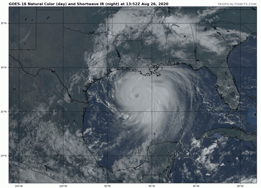
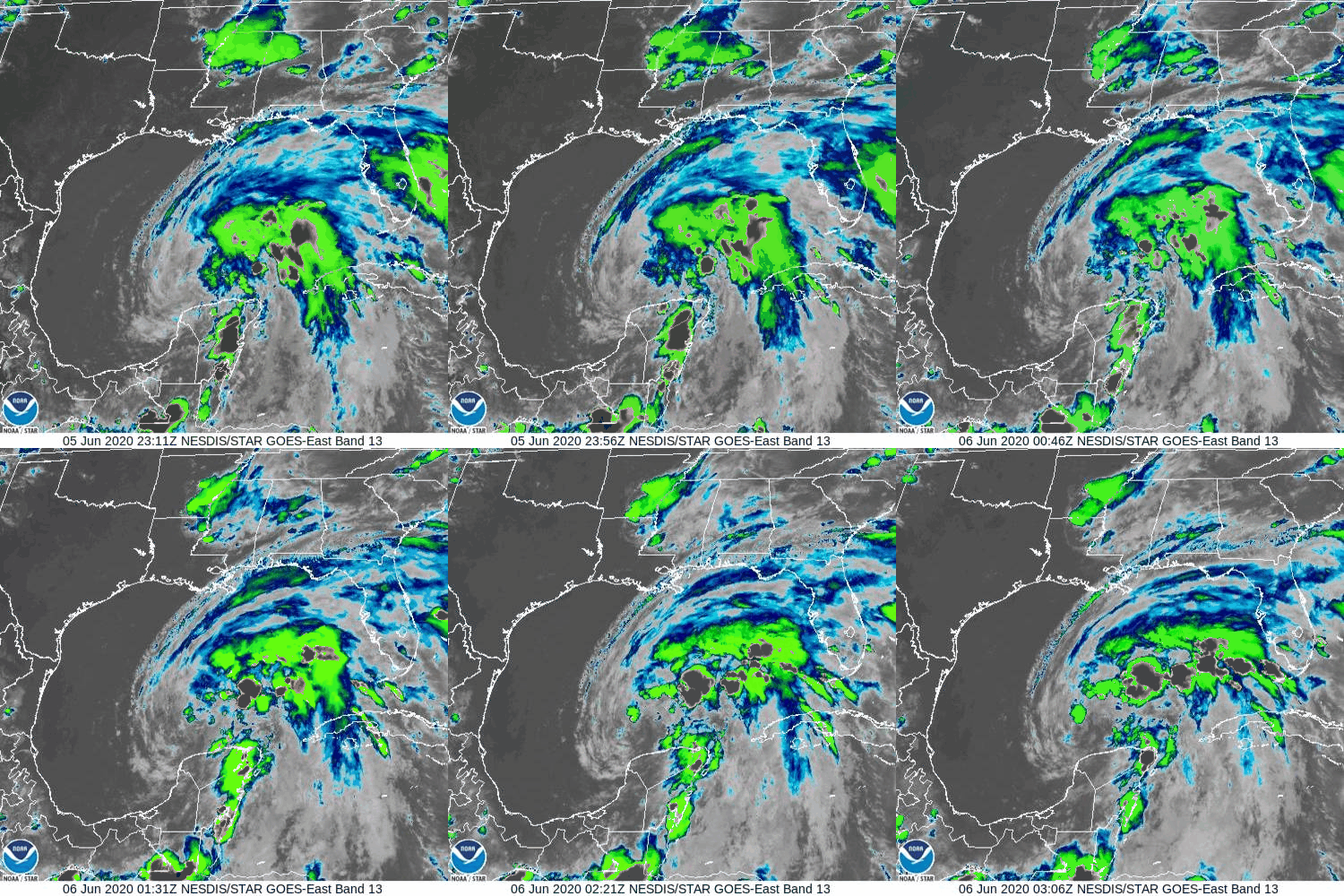
Cristobal is become a little better organized this evening. Loop provided by NOAA.

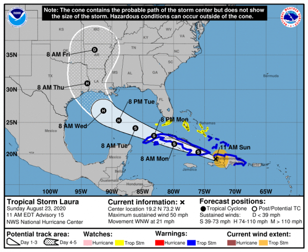
As of Friday evening, Tropical Storm Cristobal was located about 440 miles south of the mouth of the Mississippi River, moving toward the north at 14 mph. Maximum sustained winds have increased to near 45 mph. Cristobal should continue moving toward the north overnight and Saturday, with some strengthening expected.

Cristobal is a bit of a lopsided system right now, with most of the rainfall along with the strongest winds all located east of the center of the storm. While some of the rainfall will eventually rotate around to the western side of the storm, the overall structure of the system likely won’t change much over the weekend. This has important implications as the system approaches land.

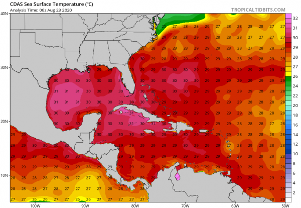
As Cristobal moves away from Mexico, some additional strengthening is expected. The waters of the Gulf are very warm, which will help the storm intensify, but the presence of dry air aloft and some wind shear will act to inhibit significant strengthening. Cristobal should strengthen a bit more on Saturday, but at this time, it does not look like it will become a hurricane before approaching the central Gulf Coast late Sunday.

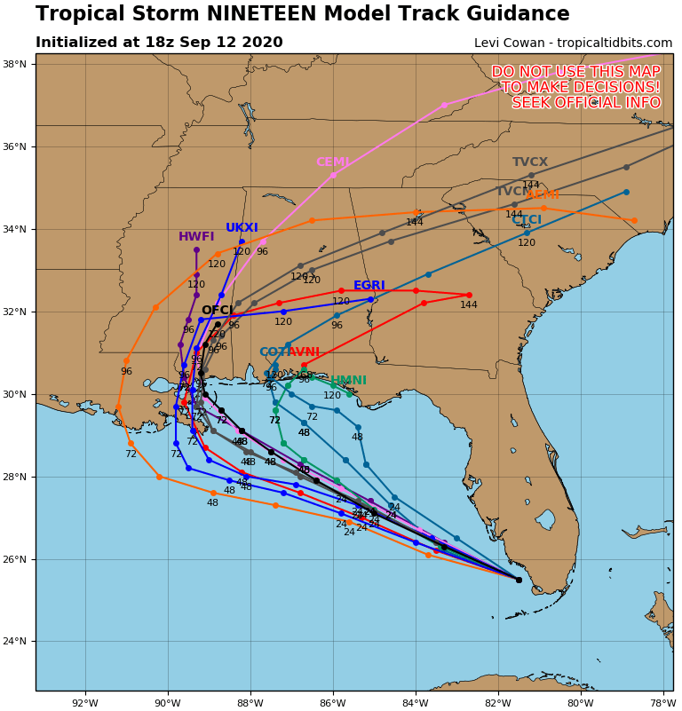
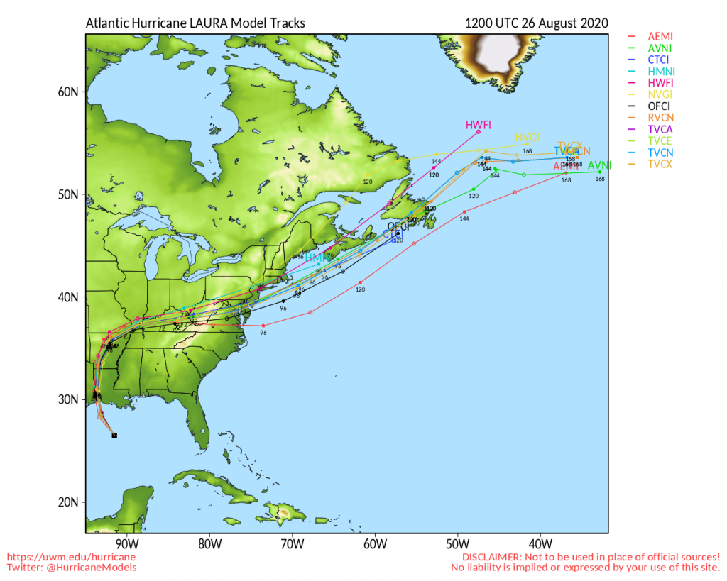
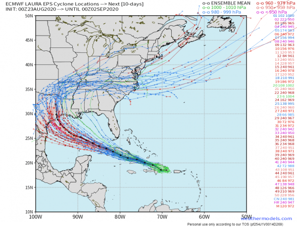
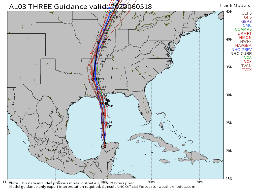
Model forecasts for the track of Cristobal. Image provided by Weathermodels.com.

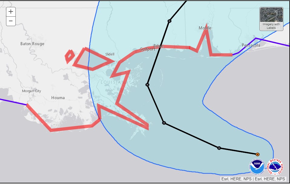
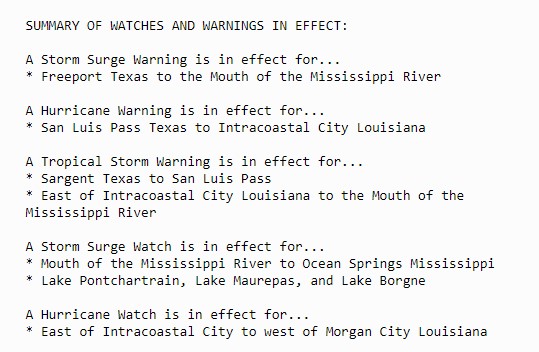
The current forecast calls for Cristobal to make landfall as a tropical storm along the coastline of Louisiana late Sunday afternoon or Sunday evening.  A Tropical Storm Warning has been issued from Morgan City, Louisiana to the border of Okalaoosa and Walton Counties in Florida. This includes Lakes Ponchatrain and Maurepas. A Tropical Storm Watch is in effect west of Morgan City to Intracoastal City. A Storm Surge Warning has also been issued from the Mouth of the Mississippi Rover to Ocean Springs, Mississippi, including Lake Borgne. A Storm Surge Watch is in effect from the Mouth of the Mississippi River westward to Morgan City, Louisiana, and also along the coast of Florida from Indian Pass to Arepika.

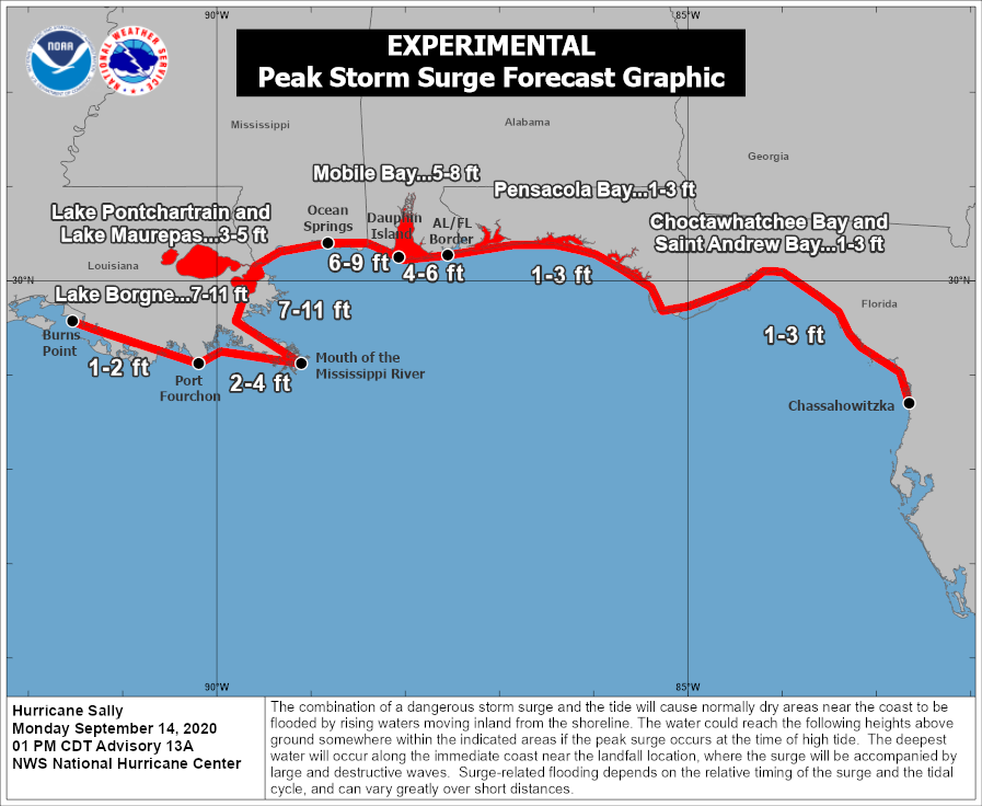
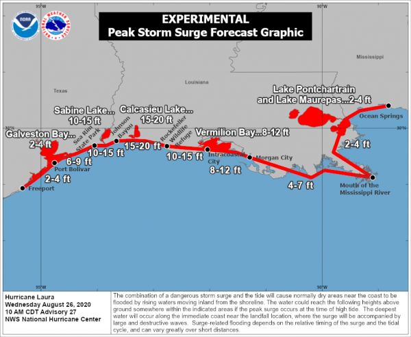
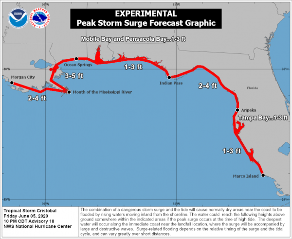
Storm surge of up to 3-5feet is expected along parts of the Gulf Coast as Cristobal moves inland. Image provided by the National Hurricane Center.

As mentioned earlier, Cristobal is a bit lopsided, and this should still be the case as the storm moves inland Sunday night. That’s not to say that areas west of the center will escape without issues, but they shouldn’t be as problematic. There will still be some heavy rain, and wind gusts to 30-40 mph, but this isn’t anything the region hasn’t experienced plenty of times before. Near and east of the center are where the problems will become more numerous.

Cristobal should have sustained winds of 50-60 mph near the center at landfall, but these winds will only be experienced over a small area along the coast. The remainder of the area will likely have sustained winds of 30-40 mph, with some gusts to 50-60 mph. Along the coast, a storm surge of up to 3-5 feet will result in flooding of some areas, especially the low-lying locations near the Mississippi River entrance. By far, the biggest threat is heavy rain.

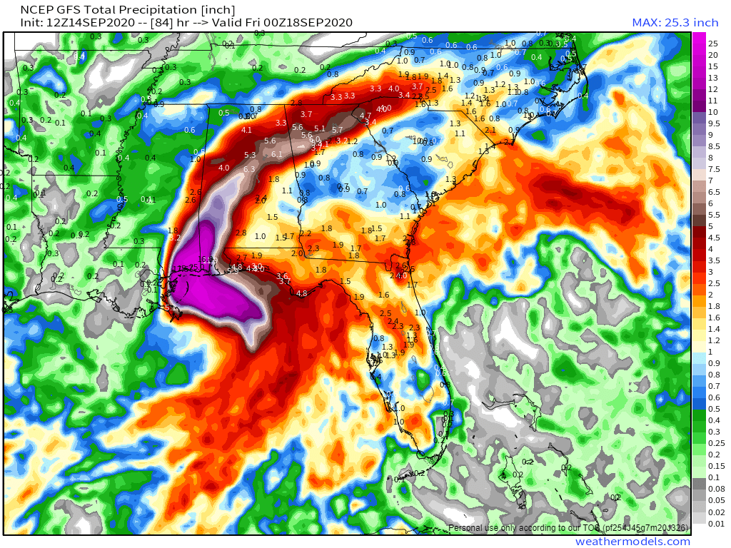
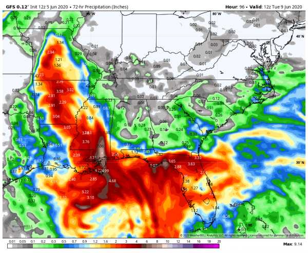
Rainfall totals of 4-8 inches are expected across a wide area, with isolated totals to 12 inches possible. This will lead to flooding across much of the region. Flood watches have already been issued. Parts of the Gulf Coast have actually been in a drought recently, but too much rain in a short period isn’t a good thing. Once inland, Cristobal should weaken and head northward, bringing heavy rain to parts of the Mississippi Valley and the Great Lakes early next week.

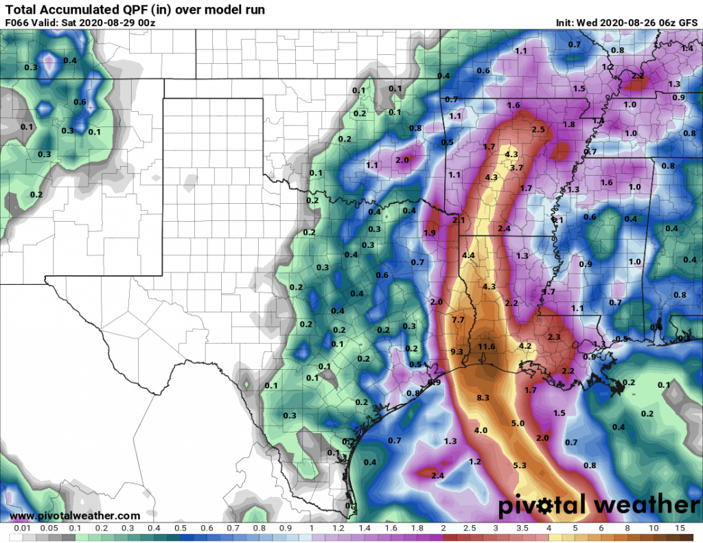
GFS forecast for rainfall from Saturday through Tuesday morning across the Gulf Coast, Image provided by WeatherBell.

Tropical Depression Three formed in the Bay of Campeche Monday afternoon and strengthened into Tropical Storm Cristobal Tuesday afternoon. It made landfall along the coast of Mexico Wednesday morning, and has been drifting around southeastern Mexico and Guatemala for the past 48 hours. Cristobal has produced torrential rainfall, with 15-25 inches of rain reported across much of the region, resulting in widespread flooding. Another 3-6 inches of rain, possibly more, is expected across this region before the system pulls away over the weekend.

Hurricane Season 2020 is Off to a Fast Start

The 2020 Atlantic Hurricane Season saw two storms form during the month of May, Tropical Storm Arthur grazed the Outer Banks of North Carolina and Tropical Storm Bertha moved into South Carolina, marking the 6th year in a row that we had at least one named tropical system in the Atlantic before the “official” start of Hurricane Season, which runs from June 1 through November 30. That’s just the start of what looks to be an active hurricane season. With Tropical Depression Three forming in the Bay of Campeche Monday afternoon, our third named storm may not be far behind.

The list of Tropical Cyclone Names for the Atlantic for this season. Image provided by the National Hurricane Center.


Arthur produced wind gusts of up to 45 mph across the Outer Banks of North Carolina, with rainfall of 3-5 inches resulting in some flooding on May 18. Otherwise, it was a rather unremarkable storm, which is rather typical for early-season storms. Last week, Bertha brought heavy rain into parts of South Carolina. This is the 6th time since 1851 that we’ve had 2 named storms form before June 1 (1887, 1908, 1951, 2012, and 2016 are the others). Despite the early start for the past several years, the average date for the first named storm in the Atlantic is still in late June or early July. Over 97% of all named storms in the Atlantic form between June 1 and November 30. Like our first two storms this year, most early season storms tend to be on the weaker side. A hurricane hasn’t made landfall in the United States before July 1 since Hurricane Bonnie came ashore as a minimal hurricane near the Texas/Louisiana border on June 26, 1986.

Based on climatology, the most likely spots for an early season storm are in the Gulf of Mexico or northwest Caribbean. Image provided by the National Hurricane Center.


Tropical Depression Three developed in the Bay of Campeche Monday afternoon. The system is the remnants of Eastern Pacific Tropical Storm Amanda, which moved into southern Guatemala on Saturday. It has been producing heavy rainfall across portions of Guatemala, El Salvador, Honduras, and southeastern Mexico since Friday, and that will likely continue for another couple of days as the system mills around in the Bay of Campeche. Conditions are favorable for development, and the system could be upgraded to Tropical Storm Cristobal on Tuesday. Since this seems likely, the government of Mexico has issued a Tropical Storm Warning from Campeche to Puerto de Veracruz. If the system is named in the next few days, it will be the earliest we’ve ever had a “C” storm in the Atlanic. The previous record was June 5, 2016, when Tropical Storm Colin was born.

Rainfall totals of 10-20 inches and locally heavier will likely produce flooding and mudslides across the region this week. Image provided by WeatherBell.


The forecast for TD 3 is fairly straightforward for the next few days. The system should mill around in the Bay of Campeche, producing heavy rainfall across southeastern Mexico, with some strengthening likely. As we get into the latter half of the week, things gets significantly more complicated. There are two distinct scenarios presented by the various computer models tonight. The first option is that the system turns northward, and moves across the Gulf of Mexico, heading towards the northern Gulf Coast towards next weekend while strengthening. The second option is that the system moves into southeastern Mexico and dissipates, then a new storm forms near or north of the Yucatan Peninsula, and heads northward later in the week. Either way, residents of the Gulf Coast should pay attention to the progress of this system as as the week goes on.

Computer model forecasts for Tropical Depression Three. Image provided by Tropical Tidbits.


An early start is not always a harbinger of what the season will bring. NOAA issued their seasonal hurricane outlook last Wednesday, and it calls for a 60 percent chance for an above normal season, a 30 percent chance for a normal season, and a 10 percent chance for a below normal season. Many of the other hurricane outlooks issued by various outlets are also expecting a busy season, due to a number of factors. An average season consists of 12 named storms, of which 6 become hurricanes and 3 become major hurricanes (Category 3 or higher on the Saffir-Simpson scale). NOAA’s forecast for this season calls for 13-19 named storms, 6-10 hurricanes, and 3-6 major hurricanes. The Tropical Meteorology Project at Colorado State, the first group to forecast how active a hurricane season would be, originally led by Dr. Bill Gray, will issue their forecast on June 4. Their initial forecast from April called for 16 named storms, 8 hurricanes, and 4 major hurricanes. They also pegged the chance at a storm making landfall in the United States at 69% (52% is the average in any given year), and the odds of a storm making landfall along the East Coast at 45% (31% is the average). The last 5 seasons have all featured above normal activity across the Atlantic.
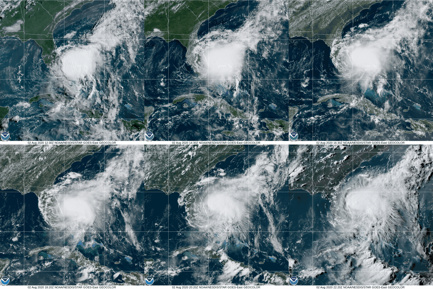
The 2019 Hurricane Season was an active one across the Atlantic Basin. Image provided by the National Hurricane Center.


A busy season does not always mean that multiple storms (or any storms for that matter) will impact the United States. In 2010, 19 named storms were observed in the Atlantic, 12 of them became hurricanes, and 5 were major hurricanes. Only one storm made landfall in the United States, and that was Bonnie, which was a minimal tropical storm at landfall. On the flip side, an inactive year doesn’t mean much for landfall probabilities as well. Only 7 named storms formed in 1992, and the 1st one didn’t develop until August 16. That storm, however, was named Andrew, and it made landfall just south of Miami as a category 5 storm.

Atlantic Hurricane Season Starts in Mid-May Again

For several days, most of the forecast models have been showing the potential for a tropical or subtropical system to develop in or near the Bahamas this weekend. Potential became reality Saturday evening when Tropical Depression One formed.

Tropical Depression One has developed north of the Bahamas. Image provided by NOAA.


As of 8pm EDT, newly-formed Tropical Depression One was centered about 175 miles east-northeast of Melbourne, Florida, moving toward the northeast at 14 mph. Maximum sustained winds were near 35 mph. With favorable upper-level conditions and the system sitting over the warm waters of the Gulf Stream, strengthening is expected, and the system will likely be upgraded to Tropical Storm Arthur tonight or on Sunday.

Forecast track for Tropical Depression One. Image provided by the National Hurricane Center.


A general north-to-northeast track is expected over the next few days, which could bring the center very close to the Outer Banks of North Carolina on Monday. As a result, a Tropical Storm Watch is now in effect for the coast of North Carolina from Surf City to Duck, including Pamlico and Albemarle Sounds.

Rain and gusty winds across the northwestern Bahamas and the east coast of Florida will wind down tonight, but rain should spread into the Carolinas later Sunday. The heaviest rain is expected from eastern North Carolina into the Delmarva Peninsula Monday into Tuesday, where as much as 2-4 inches could fall, leading to some localized flooding.

Rainfall forecast through Tuesday morning from the GFS. Image provided by WeatherBell.


Once it gets past the Carolinas, the official forecast track from the National Hurricane Center calls for the storm to turn toward the east-northeast and head out to sea while becoming extratropical, but this is far from a lock. An upper-level low pressure system will be moving into the Mid-Atlantic states and some models show the potential for the upper-low to capture the storm, and let it meander around near or just off the East Coast for several days as an extratropical system, with a large high pressure area to the north blocking it from moving farther up the coast. This would result in several days of damp and breezy conditions from the Carolinas possibly into Southern New England. Once we get towards Monday, we should hopefully have a better idea of what the storm will do.

While Hurricane Season in the Eastern Pacific Ocean starts on May 15, Hurricane Season in the Atlantic Basin does not officially start until June 1. However, as we’ve seen already several times, Mother Nature keeps her own calendar. This is actually the 6th year in a row that we’ve had a tropical system develop in the Atlantic Basin before June 1.

While Tropical Depression One will grab the weather headlines, it’s not the only tropical system that is active in the world right now. A much bigger threat has developed in the Bay of Bengal. Tropical Cyclone 01B (Amphan – pronounced UM-PUN) developed early Saturday, and is already strengthening quickly. As of late Saturday afternoon, storm has maximum sustained winds near 50 mph, and is expected to continue strengthening rapidly while heading off towards the north. Current forecasts have the storm making landfall in either Bangladesh or extreme eastern India by Tuesday or Wednesday. By that point, maximum sustained winds could be in excess of 110 mph.

Forecast track for Tropical Cyclone 01B (Amphan). Image provided the India Meteorological Department


Strong winds would obviously be a significant hazard, but history has shown several times that the biggest threat with tropical cyclones in that part of the world is flooding, both from storm surge and torrential rainfall. Much of that region lies near sea-level and is very densely populated. In the past, storms that hit this area have resulted in tens of thousands, if not hundreds of thousands of deaths. Given what is already going on around the world, this would make the situation exponentially worse.

Tropical Update – The Atlantic is a Lot More Active

Hurricane Dorian continues to blast Grand Bahama Island this afternoon, but elsewhere, the Atlantic is getting active quickly.

As of early Wednesday morning, Hurricane Dorian was centered about 80 miles east-northeast of Cape Canaveral, Florida. After sitting over the Bahamas for a couple of days, Dorian is now moving toward the north-northwest at 7 mph. After peaking as a Category 5 on Sunday, Dorian has weakened to a Category 2 hurricane this afternoon, with maximum sustained winds near 110 mph.

Dorian’s eye shows up rather nicely on radar from Florida early this morning. Image provided by Weathertap.


At it’s peak, Dorian had sustained winds of 185 mph, which is tied for the 2nd highest on record in the Atlantic Basin, and the highest for a storm that far north. Only Hurricane Allen in 1980 was stronger, with top winds near 190 mph. Dorian’s lowest pressure of 910mb, is tied for the 9th lowest on record in the Atlantic. It is the strongest hurricane ever to make landfall in the Bahamas.
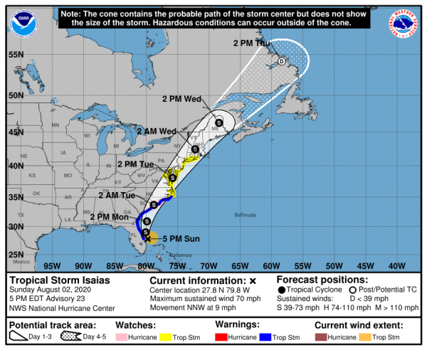
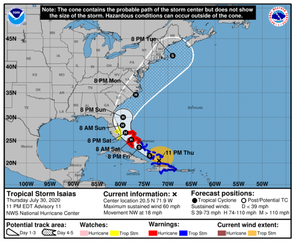
As for Dorian’s future, the thinking really hasn’t changed much in the past few days. The slow north-northwestward motion has started, and a turn more toward the north with some acceleration is expected today as a trough of low pressure approaches the East Coast. This should keep the center of the storm 75 miles or so off the Florida coastline. Dorian is expected to maintain its current intensity for the next day or two, but some minor re-strengthening is possible as the storm remains over very warm water and in an area of low wind shear. Likewise, it could weaken a bit as it is still fairly close to land. The outer bands of Dorian will continue to impact coastal Florida today, with bouts of heavy rain and gusty winds at times. A Hurricane Warning remains in effect from central Florida up into parts of North Carolina.

Model forecasts for the track of Hurricane Dorian. Image provided by Tropical Tidbits.


To the north, Dorian should start to turn northeastward later today into Thursday, coming very close to the coastline of both South and North Carolina. This will bring hurricane conditions to these states. As previously mentioned, Hurricane Warnings are in effect for parts of the area, with a Hurricane Watch in effect from Surf City, NC, to the NC/VA border. Although the official forecast from the National Hurricane Center keeps the center offshore, it will be close enough that even a slight wobble to the left could result in landfall. Whether it makes landfall or not, strong winds, torrential rainfall and very rough surf are expected in these areas over the next couple of days.

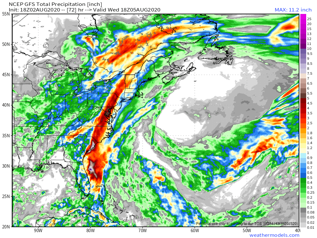
GFS forecast for rainfall across the Southeast through Saturday morning. Image provided by Weathermodels.com.


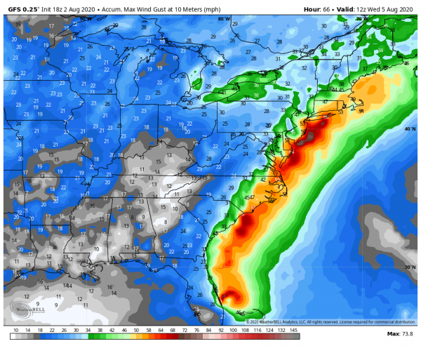
Once past the Carolinas, Dorian should continue northeast, and start to transition into an extratropical storm. That doesn’t mean that it’s done impacting land though. It could graze Cape Cod and the Islands with some rain and gusty winds late Friday into early Saturday, but over the weekend it will likely have a significant impact on Atlantic Canada. Heavy rain is likely across parts of Nova Scotia, New Brunswick, Prince Edward Island, and into Newfoundland. While some locations could pick up 2-4 inches of rain, the biggest impact will be from the wind. Sustained winds of 30-50 mph are expected with gusts of 60-70 mph or more, especially along the coastline. One other impact that you might not normally expect – across parts of Labrador and possibly northern Newfoundland, it will be cold enough for the rain to fall as snow, with several inches possible in parts of Labrador.

Peak wind gusts expected across Atlantic Canada through Sunday evening according to the GFS. Image provided by WeatherBell.


Dorian isn’t the only active storm in the Atlantic any more. Tropical Storm Fernand formed Tuesday afternoon in the Gulf of Mexico. As of early Wednesday morning, it was centered about 90 miles southeast of La Pesca, Mexico, moving toward the west at just 3 mph. It has maximum sustained winds near 50 mph, and it may strengthen a little more over before landfall in northeastern Mexico later today. A Tropical Storm Warning has been issues for parts of northeastern Mexico. The biggest impact from Fernand likely to be from heavy rainfall. Rainfall totals of 6-12 inches and locally heavier will produce flooding and mudslides across the area. Heavy rain is expected across parts of South Texas, where 2-4 inches may fall, resulting in some flash flooding.

Forecast track for Tropical Storm Fernand. Image provided by Pivotal Weather.


We’re not done yet, as Tropical Depression 8 formed Tuesday evening well out in the Atlantic. As of early Wednesday morning, the system was centered a little more than 600 miles west of the Cape Verde Islands, moving toward the northwest at 8 mph. It has maximum sustained winds near 35 mph, and will likely strengthen into a tropical storm later today. It is expected to continue on a northwest track for the next several days, staying over open water the entire time and presenting no threat to any land areas.
Forecast track for Tropical Depression 8. Image provided by the National Hurricane Center.


Yet another disturbance is located just northwest of Bermuda early this morning.  It may bring some squally weather to Bermuda today before it pulls away from the area. Conditions are marginally favorable for development for the next day or two, but by late week, it will move into an area where development is unlikely.This system is not well-organized, and conditions aren’t very favorable for further development. It will be monitored over the next few days, and may bring some squally weather to Bermuda later this week.

Model forecasts for the track of a tropical disturbance near Bermuda. Image provided by Tropical Tidbits.


If that’s not enough, there’s another wave still over western Africa that will move into the Atlantic later this week. Forecast models are showing the potential for that wave to develop as well. This shouldn’t be a big surprise, September is the peak of hurricane season.

Satellite loop of the Atlantic showing Fernand on the left edge of the screen, Dorian near the Bahamas, a disturbance near Bermuda, TD 8 west of the Cape Verde Islands and another disturbance in the eastern Atlantic moving off the west coast of Africa. Image provided by the College of DuPage.


This is just the Atlantic – we didn’t even get into the Pacific, where Hurricane Juliette is a Category 3 Hurricane southwest of Mexico, Typhoon Lingling is passing east of Japan on its way towards Korea, Tropical Storm 14W is expected to become a typhoon passing north of the Northern Mariana Islands on its way towards Japan, and Tropical Depression Kajiki is dissipating along the coast of Vietnam.

Hurricane Dorian Nears the Bahamas

Powerful Hurricane Dorian is expected to smash the Northwestern Bahamas on Sunday before heading towards the Southeastern United States.

As of 2am Sunday, Dorian was centered about 95 miles east of Great Abaco Island in the Bahamas, moving toward the west at 8 mph. Maximum sustained winds are near 150 mph, making Dorian a Category 4 Hurricane on the Saffir-Simpson Scale. Hurricane Warnings been been issued for the Northwestern Bahamas except for Andros Island, which is under a Hurricane Watch. A Tropical Storm Watch has been issued for the east coast of Florida, from Deerfield Beach to Sebastian Inlet.

The eye of Hurricane Dorian is easy to see on radar from the Bahamas Saturday evening. Image provided by the Bahamas Meteorology Department.

Dorian’s immediate future is fairly clear – it will continue westward overnight and into Sunday, passing very close to Freeport in the Bahamas as a powerful hurricane. Rainfall totals to 10-20 inches or more along with a storm surge of 10-15 feet will result in flooding along the coast and across the interior of the islands. While some additional strengthening is possible, some fluctuations are also possible as Dorian will likely start to undergo an eyewall replacement cycle at some point in the next 12-24 hours. The eyewall is where the strongest winds and most intense rainfall of a system are located. In an eyewall replacement cycle, the eyewall starts to collapse, and a new one forms a little farther away from the eye. This new eyewall eventually contracts closer to the eye, but in the meantime, it allows a storm to weaken. These are nearly impossible to predict, but they do occur in most hurricanes, mainly intense ones.

After Dorian moves through the Bahamas, things get very tricky. Dorian is currently being steered westward by a ridge of high pressure located to its north. As a trough of low pressure moves into the Tennessee Valley, it will erode that western edge of that ridge, leaving Dorian in an area with little flow to steer it. It may stall out or move very little late Sunday and Sunday night, which is bad news for the Bahamas, as much of the circulation may remain over the northwestern Bahamas, resulting in catastrophic damage for parts of the region. If Dorian stays in the same place long enough, it may bring cooler water up to the surface in a process known as upwelling. Hurricanes need warm water to help fuel them, so sitting over cooler water could help Dorian to weaken a bit.

After that, as the ridge continues to erode and the trough advances eastward, a turn toward the north and eventually northeast is expected. Exactly when this turn occurs is still a rather large question mark. While the majority of the forecast models show this turn occurring offshore, not all of them do. This is mostly good news for Florida, as it would likely keep the worst effects offshore, though gusty winds, some rainfall, and rough surf are still likely along the coast. How far inland the rain and wind penetrate will be determined by the eventual track.

Computer model forecasts for the track of Hurricane Dorian. Image provided by Tropical Tidbits.

This is bad news for portions of the Southeast, especially coastal portions of the Carolinas. A track close to the coastline in these areas seems a bit more probable at this point, which means, strong winds, heavy rainfall, and rough surf are likely for a prolong period during the middle of the upcoming week. Although the forecasts are for the center of the storm to remain offshore, it would not take much of a deviation for the center to make landfall, which would increase the threat for damaging winds and storm surge.

GFS model forecast for rainfall through Friday. Image provided by weathermodels.com

After forming last weekend, Dorian crosses Barbados and Saint Lucia as a tropical storm last Monday night. After reorganizing a little to the north, it then passes just east of St. Croix in the US Virgin Islands on Wednesday strengthening into a hurricane as it moved across St. Thomas, where it produced sustained winds as high as 82 mph with a gust to 111 mph.

Tropical System Developing in the Gulf of Mexico

It’s been a fairly slow start to hurricane season in the Atlantic, which is fairly normal, but things are starting to heat up in the Gulf of Mexico.

Thunderstorm activity is getting more organized in the northern Gulf of Mexico this afternoon. Loop provided by NOAA.


A disturbance dropped southward from the Tennessee Valley over the weekend, moving into the Gulf of Mexico on Tuesday. With plenty of warm water and only a little wind shear, the system is starting to get organized this afternoon, and could become a tropical depression later today or on Thursday.

As of 2pm Wednesday, the system was centered about 155 miles east-southeast of the mouth of the Mississippi River, moving toward the west-southwest at 8 mph. It is producing sustained winds of 30 mph, with some higher gusts. Steady strengthening is expected for the next few days. A Tropical Storm Watch has been posted from the Mouth of the Mississippi River to Morgan City, Louisiana. A Storm Surge Watch has also been posted from Pearl River to Morgan City.

Forecast tracks for Potential Tropical Cyclone Two from various forecast models. Image provided by WeatherBell.


The forecast models are fairly unanimous that the system will continue westward for the next 36-48 hours, but after that point things become unclear. A turn toward the northwest and eventually north is expected as an upper-level trough moves into the Great Plains, but when that turn occurs has a very significant impact on the system. A quicker turn means that the storm spends less time over the warm waters of the Gulf, and thus has less time to strengthen. A later turn means the opposite, more time over water, more time to strengthen, and the greater likelihood of it becoming a hurricane. Intensity forecasts are notoriously poor to begin with, and this system is no different. Very few models are predicting the system to reach hurricane strength, but the National Hurricane Center’s official forecast does call for the system to become a hurricane before landfall. As we mentioned already, the eventual track of the system will play a large part in determining this.

Intensity forecasts from various models for Potential Tropical Cyclone Two. Image provided by the University of Wisconsin.


Storm surge is a danger with any storm system, and this one is no different. Storm surge of 2-4 feet is likely near where the center makes landfall. Since much of southern Louisiana is already low-lying, this could result in flooding for much of the region. Wind damage will also be a concern across the region, which again will be dependent on the strength of the system. Winds will pick up Friday night across portions of Louisiana and possibly eastern Texas, with landfall most likely on Saturday right now, but this is obviously subject to change.

Rainfall forecast for the Gulf Coast for the next 6 days. Image provided by Weathermodels.com

By far, the biggest threat with this system will be rainfall. Tropical systems produce copious amounts of rainfall, and this one will be no different. Rainfall totals of 6 to 12 inches are expected across parts of the Gulf Coast, with some amounts to 20 inches possible. This would produce widespread flooding across the region, but in this case, it will just exacerbate existing flooding problems. The Mississippi River remains above flood stage across the region, and this will only worsen the flooding. On top of that, thunderstorms dropped up to 10 inches of rain on parts of New Orleans Wednesday morning, and that’s before the precipitation from the system even reaches the area. The Mississippi River is expected to crest in New Orleans at a level of 20 feet, which is also the same height that the levee system protects the city to. Obviously this will bear watching. Upstream, the River has been above “Major Flood” stage in Baton Rouge since February 26. It’s not likely to drop below flood stage until at least some time in August, if then.

River forecast for the Mississippi River at New Orleans. Image provided by NOAA.


Elsewhere, the Atlantic remains quiet, with no other systems expected to develop in the next week or so.

M is for Mayhem

For the third year in a row, the “M” storm in the Atlantic is prepared to wreak havoc on a populated area, but Michael isn’t the only headline maker in the weather at the moment.

Hurricane Michael isn’t the only storm in the news, but it is the biggest threat at the moment. As of early Tuesday afternoon, Michael was centered about 335 miles south of Panama City, Florida, moving toward the north at 12 mph. Maximum sustained winds are near 110 mph, making Michael a Category 2 Hurricane. Additional strengthening is expected over the next 12-18 hours as the storm moves over the warm waters of the eastern Gulf of Mexico. Hurricane and Storm Surge Warnings are in effect for the Florida Panhandle and the Big Bend area of Florida, with Tropical Storm Warnings and Watches surrounding the Hurricane Warnings. Tropical Storm Watches are also in effect for the Atlantic coast from northeastern Florida into South Carolina.

Forecast track for Hurricane Michael. Image provided by the National Hurricane Center.

Michael is expected to make landfall in the Florida Panhandle Wednesday afternoon, likely as a Category 3 storm. Strong winds, torrential rainfall, storm surge, and some tornadoes are all possible with this storm. Unlike Florence, which hung around the Carolinas for days and dumped incredible amounts of rainfall on the region, Michael is expected to keep moving at a steady pace, emerging off the Mid-Atlantic coast by Friday morning. Rainfall totals of 5-10 inches are still expected in parts of the region, which will produce flooding in some areas, especially in Carolinas, where many areas are still recovering from Florence. Right along the coast, a storm surge of 6-12 feet is possible, especially in the Big Bend area of Florida. Fortunately, this area is not heavily populated, but for the residents that do live in this area, storm surge flooding is a significant threat.

This is the 3rd year in a row that the “M” storm is expected to result in significant damage to a populated area. In 2014, Category 5 Hurricane Matthew left a path of death and destruction across parts of Haiti, Cuba, the Bahamas, and eventually parts of the southeastern United States. Last year, Category 5 Hurricane Maria devastated the northeastern Caribbean, including Puerto Rico and the US Virgin Islands. While Michael is not expected to become a Category 5 storm, it is still expected to result in significant damage to parts of Florida and the Southeast.

Satellite loop of Tropical Storm Leslie. Loop provided by NOAA.

Meanwhile, in the eastern Atlantic, Tropical Storm Leslie refuses to go away. As of midday Tuesday, Leslie was centered a little more than 1000 miles west-southwest of the Azores, moving toward the south-southeast at 13 mph. Maximum sustained winds are near 65 mph. The forecast for Leslie calls for a turn more toward the east over the next few days while it strengthens back into a hurricane. Leslie is expected to remain over open waters for the next few days, and could become an extratropical storm this weekend while continuing on a general easterly track.

To the south, Tropical Storm Nadine as formed nearly 500 miles southwest of the Cabo Verde Islands. Nadine has maximum sustained winds near 40 mph, and is moving toward the west-northwest at 9 mph. Nadine is expected to remain fairly weak over open waters for the next several days while turning more toward the northwest. As it moves over colder water late this week and this weekend, it should weaken and eventually dissipate.

Back in the United States, unseasonably warm conditions remain in place across much of the eastern half of the nation. Temperatures are in the 70s and 80s across much of the region, which is 15 to 25 degrees above normal. A strong frontal system is located in the Plains states this afternoon, separating the warm air in the East, from much cooler weather behind it in the Plains and the Rockies. Right along this front, which hasn’t moved much for the past 24 hours, severe weather and heavy rainfall are common this afternoon.

National radar loop from early Tuesday afternoon. Loop provided by Weathertap.

Several tornadoes have been reported already today, including a few in the Oklahoma City area, and more are expected later today and tonight. Heavy rainfall is also expected from Texas into the Central Plains and parts of the Upper Midwest. Rainfall totals of 1-3 inches and locally heavier may produce flash flooding in some areas. Flash flood watches are in effect for much of the region.

Snowfall forecast through Thursday morning from the WRF model. Image provided by Pivotal Weather.

On the other side of the front, where much cooler weather is in place, rain is expected to change over to snow as low pressure rides along the front and into the Midwest. Winter weather advisories have already been posted for parts of the region. Snow is already falling in parts of Colorado this afternoon, and several inches may fall over the next 36-48 hours from western portions of Kansas and Nebraska into the Dakotas and northern Minnesota.

Multiple Tropical Systems Threatening Land

As we hit the climatological peak of hurricane season, we still have several storms that are threats to land in both the Atlantic and Pacific Ocean.

The storm that is rightfully gaining the most attention is Hurricane Florence. As of midday Tuesday, Florence was centered about 390 miles south of Bermuda, moving toward the west-northwest at 16 mph. Florence reached Category 4 strength Monday evening, before undergoing and eyewall replacement cycle. What that means is that the intense thunderstorms surrounding the eye of the storm essentially weaken, but a new ring of storms forms farther away from the center. These eventually contract to form a new eyewall. While this will weaken a storm a bit, it also expands the radius of the wind field. Now that Florence has undergone this process (which will likely happen again at some point in the next day or two), its maximum sustained winds have decreased to around 130 mph, making it a Category 3 hurricane. A Hurricane Watch and Storm Surge Watch have been issued for most of the coastline of North Carolina and South Carolina.

Model forecasts for the track of Hurricane Florence. Image provided by WeatherBell.

Florence is expected to continue in a general west-northwest direction for the next day or two, with more strengthening expected. It should regain Category 4 status later today, and there is a chance it could reach Category 5, depending on when the next eyewall replacement cycle takes place. By Thursday, high pressure will build in north of Florence, which will start to slow the system down as it approaches the North Carolina coastline.

Rainfall forecast through the weekend based on the GFS model. Image provided by Weathermodels.com

Most of the forecast models show the system slowing to a crawl or even stalling out by Friday. The big question is, does it stall out before landfall or after landfall? No matter where it stalls, many of the effects will be the same, it will just determine what happens down the road. The strongest winds will be confined to areas closest to the coastline. Once the storm stalls out, especially if it is overland, it will start to weaken, with winds becoming less of a problem. Storm surge will also be a major problem, especially across the Outer Banks and Pamlico and Albemarle Sounds. By far, rainfall and resultant flooding is the largest threat. Tropical systems already produce copious rainfall, but when they stall out, the amounts become that much higher – just look at what Hurricane Harvey did to Texas last year. In this case, with the storm expected to sit near or over the Carolinas for a few days, we could be looking at rainfall totals of 15-30 inches or more, which could lead to some of the worst flooding the region has ever seen. The torrential rain will also spread into neighboring parts of Virginia as well.

To the south, Tropical Storm Isaac is a threat to portions of the Lesser Antilles. After briefly reaching hurricane status, Isaac weakened to a tropical storm on Monday. As of midday Tuesday, Isaac remained a tropical storm with maximum sustained winds near 70 mph. It was centered about 775 miles east of the Lesser Antilles, moving towards the west at 16 mph. This track is expected to continue for the next few days, and as a result, Hurricane Watches and Tropical Storm Watches have been issued for some of the islands. Isaac is encountering some westerly shear that produced the weakening on Monday, and this will likely continue, preventing the system from strengthening much, and could result in some additional weakening. Isaac will bring gusty winds and heavy rain to many of the islands as it moves through on Thursday. It should remain south of Puerto Rico and the Virgin Islands, which are still recovering from last year’s double whammy of Irma and Maria. Some locally heavy rainfall is possible from Isaac’s outer bands as it passes to the south, but a direct hit is not expected. Beyond that, Isaac may weaken further as it continues across the Caribbean Sea.

Forecast track for Tropical Storm Isaac. Image provided by the National Hurricane Center.

To the east, Hurricane Helene is starting to weaken over cooler waters in the Eastern Atlantic. As of midday Tuesday, Helene was centered about 1550 miles south-southwest of the Azores, moving toward the northwest at 12 mph. Helene’s maximum sustained winds were near 110 mph, but gradual weakening is expected over the next few days as the storm heads more toward the north. As we get toward the weekend, Helene should weaken to a tropical storm and may start to lose is tropical characteristics as it approaches the Azores. Gusty winds and heavy rain would be the main threats to the islands. Beyond that, it could impact parts of the British Isles as an extratropical system early next week.

Model forecasts for the track of Hurricane Helene. Image provided by the University of Wisconsin.

Another disturbance is moving across the northwestern Caribbean and into the Yucatan Peninsula this afternoon. This system remains disorganized for now, but as it moves into the Gulf of Mexico over the next day or two, conditions could become favorable for some development. Whether it develops or not, it will bring heavy rainfall to parts of the Yucatan today and the Gulf Coast, especially Texas, over the next several days.

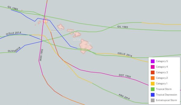
Forecast track for Tropical Storm Olivia. Image provided by the Central Pacific Hurricane Center.

In the Eastern Pacific Tropical Depression Paul is nearly 1000 miles southwest of Mexico, and expected to dissipate over open water in the next 24-36 hours. To the west, Tropical Storm Olivia is bearing down on the Hawaiian Islands. As of midday Tuesday, Olivia was centered about 440 miles east of Honolulu, moving toward the west at 10 mph. Maximum sustained winds were near 65 mph, and slow by steady weakening is expected over the next few days. Tropical Storm Warnings are in effect for most of Hawaii, except Kauai where a Tropical Storm Watch is in effect. Olivia is expected to cross the Hawaiian islands on Wednesday. Unlike Hurricane Lane a few weeks ago which produced heavy rain across the Big Island, but stayed offshore, Olivia will likely bring heavy rain and gusty winds to much of the island chain. In some of the mountain areas, especially on the Big Island, rainfall totals of 10-20 inches and locally heavy may result in flooding in some areas once again.

Satellite images showing Tropical Storm Barijat southeast of Hong Kong. Image provided by NOAA.

In the Western Pacific, Tropical Storm Barijat is expected to move across the South China Sea over the next few days while remaining weak. As of midday Tuesday, Barijat was centered about 215 miles southeast of Hong Kong with maximum sustained winds near 40 mph, moving towards the west at 12 mph. It should continue on a general westward track for the next day or soo with some strengthening possible, before crossing China’s Leizhou Peninsula late Wednesday. After that, it is expected to weaken before making a final landfall as a weak tropical storm or a tropical depression in northern Vietnam on Thursday or Friday. Heavy rain is the main threat with this system.

Forecast track for Super Typhoon Mangkhut. Image provided by the Joint Typhoon Warning Center.

The bigger story in the Western Pacific is Super Typhoon Mangkhut. At midday Tuesday, Mangkhut, located roughly halfway between the Northern Mariana Islands and northern Philippines, had maximum sustained winds near 160 mph. It is moving westward at 14 mph, but a turn more toward the west-northwest is expected over the next day or two. Mangkhut has likely not peaked in intensity yet, and could strengthen a bit more over the next 24-36 hours. The current forecast calls for Mangkhut to pass just north of the Philippines later this week, likely close enough to bring heavy rain and strong winds to Luzon. A deviation slightly to the south of the expected track could result in landfall, and significant impacts to northern Luzon. Beyond that, a track into the South China Sea and some slow weakening is expected. The storm will become an increasing threat to southern China, including Hong Kong, by this weekend.

Trouble Brewing the Atlantic and Pacific

As we reach the climatological peak of hurricane season, multiple storms are threatening land in both the Atlantic and the Pacific Ocean.

The biggest threat right now is Tropical Storm Florence. As of 11pm EDT Saturday, Florence was centered about 800 miles southeast of Bermuda, moving toward the west at 6 mph. After reaching Category 4 strength a few days ago, Florence has weakened to a tropical storm with maximum sustained winds near 70 mph. Florence will be moving into an area where conditions will be favorable for development, plus there is plenty of warm water ahead, so the system will likely become a hurricane again by Sunday. Rapid strengthening is possible over the next few days, and Florence could become a Major Hurricane (Category 3 or stronger) again over the next few days.

Forecast tracks for Florence based on the 51 members of the ECMWF Ensemble. Image provided by the University at Albany.
Forecast tracks for Florence based on the 20 members of the GFS Ensemble. Image provided by the University at Albany.


The future track of Florence still has plenty of questions that can’t be answered yet, but have significant implications. A ridge of high pressure will build in to the north of Florence, sending it on a general westward track, towards the southeastern United States. The question is, how strong is that ridge to the north of Florence, and how will it be oriented? If it’s strong enough, it will continue to drive the system west or west-northwestward, sending it into the Carolinas, Georgia, or possibly even northern Florida. If the high is weaker or sets up just a bit farther to the east, it could allow the system to turn more northward as it gets close to the coastline, which could allow it to recurve out to sea without making landfall, or it could stall close to the coastline. This will obviously determine what impacts Florence may or may not have on the Southeast (as well as the Mid-Atlantic and possibly even the Northeast) later in the week. People with interests along the East Coast, especially the Mid-Atlantic states and the Southeast, should keep a close eye on the future of Florence. Rough surf ahead of Florence will impact most of the East Coast beginning on Sunday, and continuing through the week.

Model forecasts for the track of Tropical Storm Isaac. Image provided by the University of Wisconsin.

While Florence is gathering all of the attention, it is far from the only system that is a threat to land. Newly-formed Tropical Storm Isaac was centered about 1580 miles east of the Windward Islands as of 11pm EDT Saturday, moving toward the west at 8 mph. Isaac had maximum sustained winds near 50 mph, and is expected to steadily strengthen over the next few days while crossing the Atlantic. The current forecast calls for Isaac to become a hurricane by early in the week. as we get toward midweek, if it continues on its current westward track, it could become a threat to the Lesser Antilles. Many parts of this area are still recovering from getting battered by Irma and Maria last summer, and were hoping for a quiet hurricane season. This would not be welcome news for the area.
Forecast track for Tropical Storm Helene. Image provided by the National Hurricane Center.

To the east, Tropical Storm Helene is a threat to the Cabo Verde Islands. Tropical Storm Warnings and Hurricane Watches are in effect for the islands of Santiago, Fogo, and Brava. As of 2Am EDT SUNday, Helene was centered about 120 miles southeast of the southernmost Cabo Verde Islands, moving towards the west at 13 mph. Maximum sustained winds are near 60 mph, and additional strengthening is expected. Helene could become a hurricane on Sunday. It will bring gusty winds and heavy rainfall to parts of the Cabo Verde Islands for the next 24-36 hours. Rainfall totals of 3-6 inches could result in flooding and mudslides across the islands. Once it pulls away from the islands later on Sunday, it should continue off toward the west-northwest while strengthening a bit more. By mid-week, a turn more towards the northwest is expected, with a weakening trend ensuing as Helene moves over colder waters.

Model forecasts for the track of Hurricane Olivia. Image provided by Tropical Tidbits.

Meanwhile, the Pacific remains active as well. Hurricane Olivia was centered about 930 miles east of Hilo, Hawaii Saturday evening, moving towards the west at 16 mph. Olivia has maximum sustained winds near 80 mph right now. The forecast for Olivia is for a general west to west-southwest motion over the next few days, with a gradual weakening trend expected. By mid-week, a weakening Tropical Storm Olivia is expected to cross the Hawaiian Islands. Rough surf is expected across Hawaii over the next few days, with gusty winds likely as the system approaches later on Tuesday. The main threat with this system will be heavy rain leading to flooding across the area. Hurricane Lane brought torrential rainfall and flooding to the area a few weeks ago, and this will likely renew flooding in some of the same areas that have not cleaned up yet.

Forecast track for Tropical Depression 18-E. Image provided by the National Hurricane Center.

Back to the east a bit, Tropical Depression 18-E has formed off the west coast of Mexico. As of Saturday evening, the system was centered about 670 miles southwest of Cabo San Lucas, Mexico, moving toward the west at 9 mph. Maximum sustained winds are near 35 mph, and strengthening is expected. The system should become a tropical storm on Sunday. The storm should head northwestward for the next 24-36 hours, before turning back towards the west-northwest. It should remain over open water, with no threat to any land areas. At this time, the system is not expected to become a hurricane before it starts to weaken over colder waters towards midweek.

Forecast track for Tropical Storm Mangkhut. Image provided by the Joint Typhoon Warning Center.

Heading much farther to the west, Tropical Storm Mangkhut continues to strengthen in the Western Pacific Ocean. As of Saturday evening, Mangkhut was centered about 675 miles east of Guam, moving toward the west at 23 mph. It has maximum sustained winds near 65 mph, and is expected to steadily strengthen while heading westward over the next few days. It should become a typhoon on Sunday. The system is expected to move across the Northern Mariana Islands on Monday as a strengthening typhoon. Strong winds, torrential rainfall and storm surge are all threats to the islands, including the large US military presence on Guam. It should continue on a general west or west-northwest course beyond that, possibly becoming a Super Typhoon (equivalent to a Category 4 or 5 Hurricane in the Atlantic/Eastern Pacific) by midweek. Its too early to determine where it goes beyond that, but it could become a threat to the northern Philippines, Taiwan, or southeastern China late in the week.

The Tropics Are Getting Active Again

The peak of hurricane season in the Atlantic occurs around September 10 on average. As we rapidly approach that date, the Atlantic is starting to get active, with two named systems right now.

Satellite photo from early Tuesday afternoon showing Tropical Storm Gordon near the Gulf Coast and Hurricane Florence in the Central Atlantic. Image provided by NOAA.
The biggest threat this afternoon is Tropical Storm Gordon. As of midday Tuesday, Gordon was centered about 130 miles south-southeast of Mobile, Alabama, moving towards the northwest at 15 mph. Maximum sustained winds were near 65 mph, and some additional strengthening is possible. Gordon could become a hurricane before making landfall along the Mississippi or Alabama coastline tonight Hurricane and Tropical Storm Warnings are in effect for much of the north-central Gulf Coast, with a Storm Surge Warning also in effect for parts of the area.

Rainfall totals through Friday morning based on the GFS model. Image provided by Weathermodels.com

While storm surge flooding and strong winds are threats with Gordon, heavy rain will be a more prolonged threat to the region. Once Gordon makes landfall it will slow down as it moves into the Deep South and Mississippi Valley. This will keep the heavy rain threat going for a few days. Rainfall totals of 3-6 inches, with localized totals to 10 inches or more could result in flooding across much of the region. By Friday, as the system continues to drift northward, an approaching cold front will pick up the system, and send it off towards the Ohio Valley and Great Lakes.

Meanwhile, in the Central Atlantic Ocean, Florence has become the third hurricane of the season. As of midday Tuesday, Florence was about midway between the Lesser Antilles and Cape Verde Islands, moving toward the west-northwest at 12 mph. Florence has maximum sustained winds near 75 mph, but the current forecast calls for Florence to weaken a bit over the next few days before regaining a little strength. Florence should continue in a general northwestward track through the week, remaining over open water. After that, things may get a little complicated.

Model forecasts for the track of Hurricane Florence. Image provided by WeatherBell.

The steering currents in the central Atlantic Ocean are forecast to weaken later this week, making the future track of Florence uncertain once we get into the weekend. The more likely case is what usually happens, an approaching trough of low pressure picks up Florence and it curves northward and eventually harmlessly out to sea. However, if that trough is not strong enough to grab Florence, it could meander around for a while or start to drift westward as a ridge of high pressure builds back in to the north. While Florence would still likely head out to sea eventually, this scenario would imply a potential threat to the East Coast later next week. We won’t know which scenario is more likely until we get to this weekend at the earliest.

Model forecasts for the track of a developing system in the eastern Atlantic. Image provided by Tropical Tidbits.
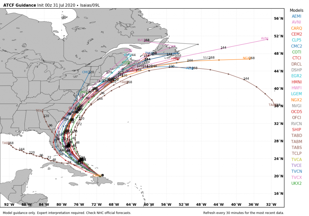
Even farther to the east, a developing low pressure system is passing south of the Cape Verde Islands today. It is expected to continue on a general west to west-northwest track over open waters for the next several days. Conditions are favorable for development, and the system could become a tropical depression later this week. It is still a week away from impacting any land areas, if it were to even get that far.

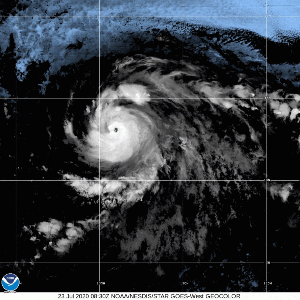
Forecast track for Hurricane Norman. Image provided by the Central Pacific Hurricane Center.

In the Pacific, Hurricane Olivia will strengthen a bit more over the next day or two as it continues to move away from Mexico and into the open waters of the Eastern Pacific. Hurricane Norman, however, is the system getting attention in that part of the world.
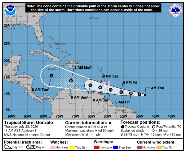
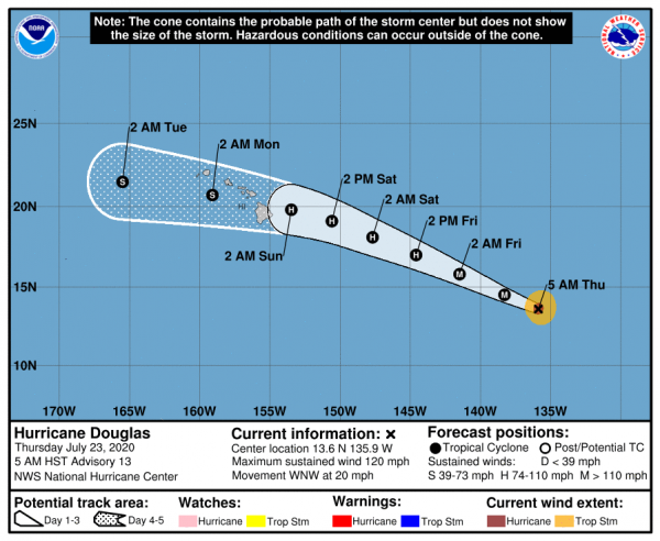
As of Tuesday morning, Norman was centered about 750 miles east of Hilo, Hawaii, moving toward the west at 17 mph. Maximum sustained winds were near 85 mph. Norman is expected to maintain its current strength for another day or two before a weakening trend begins. The system is expected to turn more toward the northwest later this week, passing safely east and north of Hawaii towards the end of the week. It will send some rough surf towards the islands, but that should be the only impact as the region continues to recover from Hurricane Lane.

Back to top