First Winter Storm of the Year for the Northeast?

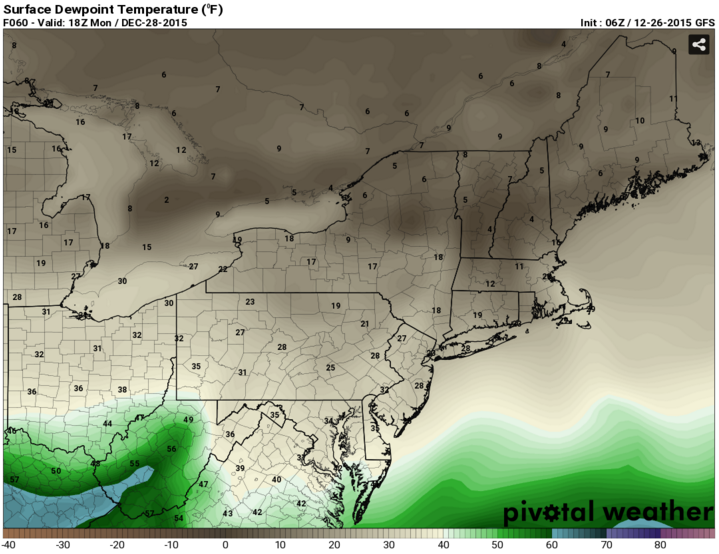
Much of the talk over the past few days has been about the record breaking temperatures around Christmas time. And rightly so, because many temperatures reached the mid to upper 60s in the East and Northeastern US breaking old records by as much as 5 to 10 degrees while many hoped for a White Christmas. This all happened at the same time as intense storms ripped through the Midwest and Southern US, leaving damage behind. However, a  quick cold shot will bring the Northeast quickly right back to reality come Monday as a piece of energy dives into the Northeast that can trace its origins to Northwestern Canada and will bring with it, very cold temperatures. Some of the coldest temperatures that the Northeast has had all winter are expected. Monday, as high pressure sits in Southeastern Canada, cold air will be able to drain south from Canada on northerly winds. Temperatures may not get out of the 30s in many spots on Monday and dew point temperatures (a measure of moisture) will be below freezing, indicating the strength of the cold and dry air.
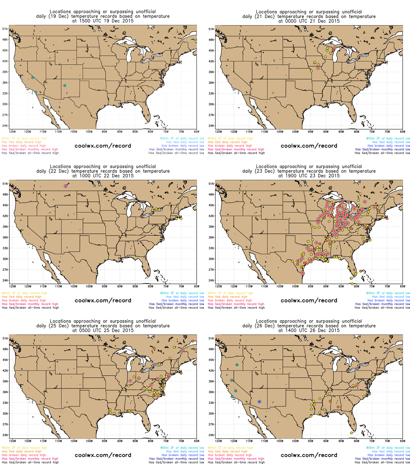
Record temperatures around Christmas time. Via coolwx.com


Dew point temperatures below freezing indicate a very cold and dry airmass before Tuesday's precipitation.
Dew point temperatures below freezing indicate a very cold and dry airmass before Tuesday’s precipitation. Via Pivotalweather.com

The strength of this cold and dry air is very important because right after this cold shot passes through, moisture will be coming up from the south in a very common setup, for what is called overrunning.  What happens is that warm, less dense, moisture from the south rides over cooler, denser air at the surface and results in precipitation. It is common for this setup to have precipitation hold off as the moisture aloft fights with the drier air at the surface to be able to reach the surface. As the moist air evaporates before it reaches the ground, it actually acts to cool the air, thus keeping temperatures near or just above the freezing mark during the day, much like sweating keeps us cool during the summertime. With surface temperatures remaining around freezing, the initial precipitation that does fall will have an opportunity to fall as wintry precipitation. Forecast atmospheric profiles, known as soundings, show that temperatures at the surface and aloft will remain below freezing as the warm moist air enters the region so the precipitation type should start as snow. However, as the warm, moist air continues to come in, especially since it will be helped along with any additional daytime warmth, midlevel temperatures will be able to warm and the atmospheric profile will begin to look like one that will produce sleet and freezing rain before eventually changing to rain by days end. The strength of the winds aloft behind the warm front (signaling the entrance of the warm, moist air) is important because this will tell how quickly the warm air mass can come in from the south and change everything to sleet, freezing rain and rain and it will tell how far inland the warm air is able to come from the ocean as the winds come in from the southeast in the form of a coastal front. If this coastal front is able to set up, snow fall amounts could be increased on the western cold side of the coastal front. In addition snowfall amounts may be bumped up just to the north of the warm front because it will have decent mid to lower level energy along it, but at the same time, most of the energy appears to be outside of the zone for best snowfall growth so total snowfall won’t be as high as it could be. The most likely time frame for the snow to occur would be the morning into the midday hours ahead of a possible change over to sleet and freezing rain, which would occur from the midday hours on and a changeover to all rain could occur in the afternoon to evening hours. Of course, if any snow accumulation does occur, rain on top of that would spell trouble for driving as slush may form on the street, further exacerbated by any sleet and freezing rain that could fall on Tuesday. Of course, there’s always the wrinkle of if a coastal low pressure system does form because this would also act to keep cooler air around longer extending the longevity that the wintry precipitation resides in New England on Tuesday instead of rainfall. The area of low pressure should then push northeast and be out of the area overnight Tuesday night.
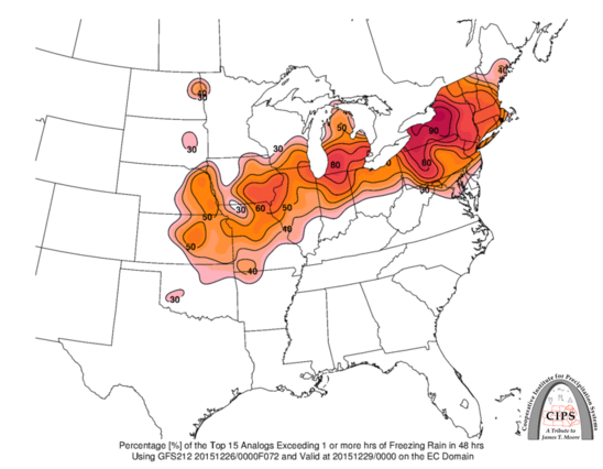
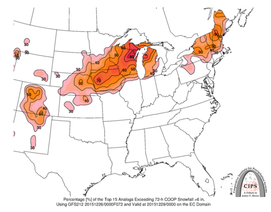
Analogs indicate the chance for freezing rain.
Analogs indicate the chance for freezing rain. Via CIPS.
Analogs indicate the chance for snowfall in New England.
Analogs indicate the chance for snowfall in New England. Via CIPS.

Snow, Rain and Severe Weather in the Central US, Record Warmth in the East

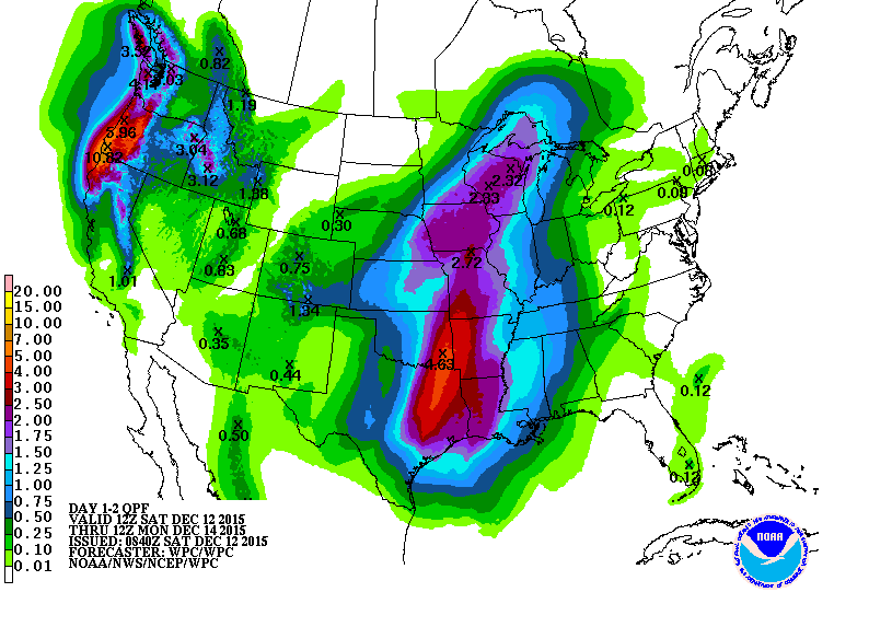
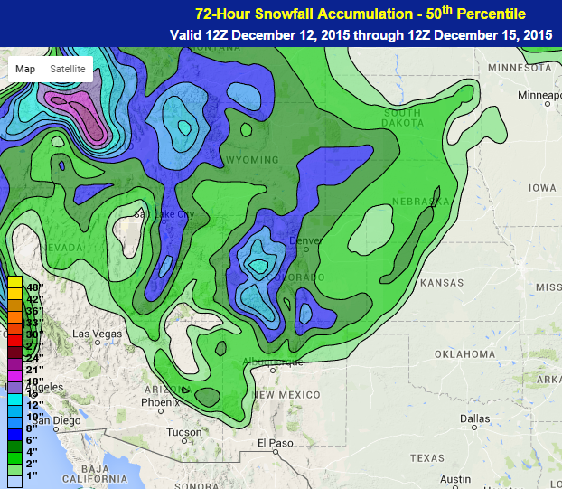
A low pressure system that formed on Saturday and will intensify into Monday as it moves from the Southern Plains into the Great Lakes and eventually into the Northeast by Monday night. Saturday night will see showers and thunderstorms in the Southern Plains ahead of, and especially along, a cold front extending southward from the system. That cold front will move from the Southern Plains and into the Tennessee River Valley and parts of the Southeast with strong winds and possibly a tornado being the main threats, along with flooding rainfall. As much as 2 to 5 inches of rainfall is forecast to fall by Monday morning in Northeast Texas and Eastern Oklahoma. The main limiting factor for the thunderstorms in the Southern Plains will be instability, especially with the morning cloud cover expected to remain around the region through the day. For the most part, this storm is expected to be mostly rainfall, but the outermost edges to the north and west of the storm may have a chance to change to snow, from Northern New Mexico and southeastern Colorado northeastward into Northern Minnesota. Some of the higher elevations in Colorado could see a foot or more of snow while the lower elevations could see 2 to 6 inches, especially in southern Colorado and northeastern New Mexico.

48 hour rainfall forecast. Note the higher amounts in northeast, Texas and western Oklahoma.Via WPC.
48 hour rainfall forecast. Note the higher amounts in northeast, Texas and western Oklahoma. Map provided by the National Weather Service’s Weather Prediction Center
Snowfall forecast. note the higher amounts in Colorado and New Mexico. Via WPC.
Snowfall forecast. note the higher amounts in Colorado and New Mexico. Map provided by the National Weather Service’s Weather Prediction Center.


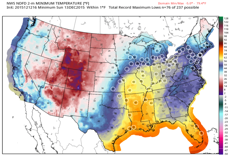
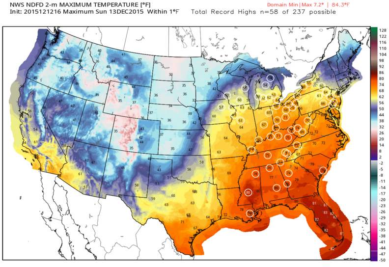
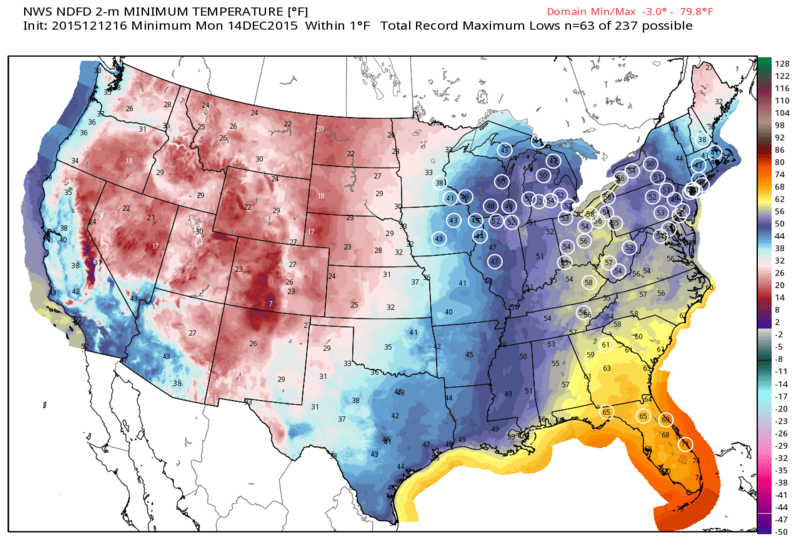
As the low pressure system intensifies, it will have quite a pull of warm and moist air from the south into the eastern half of the United States. This could result in dozens of record high temperatures and record high minimum temperatures being set across the region. In many places, the forecasts would exceed the current records by 5 to 10 degrees or more.

Record high minimum temperatures on Saturday night denoted by white circles.
Record high minimum temperatures on Saturday night denoted by white circles. Map provided by WeatherBell.
Record high temperatures circled in white especially over the eastern half of the US.
Record high temperatures expected for Sunday circled in white, especially over the eastern half of the US. Map provided by WeatherBell.
Record high minimum temperatures on Sunday night denoted by white circles.
Record high minimum temperatures on Sunday night denoted by white circles. Map provided by WeatherBell.


This pattern is almost the complete opposite of what we had at this time last year when anomalously warm temperatures were draped across most of western and central United States with below normal temperatures residing over most of Eastern United States.

Season’s First `Significant’ Snow Forecast for Chicago, Midwest

(This article originally appeared on Bloomberg.com)

The Midwest’s first snow of the season threatens to drop as much as 6 inches (15 centimeters) on Chicago through Saturday.

The storm was coming together Friday over eastern Wyoming and will move east before sweeping up the St. Lawrence River in Canada, where it should die out, said Rob Carolan, a meteorologist with Hometown Forecast Services Inc. in Nashua, New Hampshire. There may be flurries in northern New York State, while Manhattan remains untouched.

“It jets off to the east very quickly,” Carolan said. “A pretty good swath of snow could fall from eastern Nebraska up into Iowa and Michigan.”

This is “the first significant” snowfall across the central U.S., with 4 to 8 inches forecast for a large section of the country from Nebraska to Michigan and even more in some areas, the National Weather Service said. Winter storm warnings, advisories and watches stretch from Idaho to Michigan, including Chicago.

After the storm crosses the Great Lakes, it will start “to fizzle out,” Carolan said. That reduces the threat of any measurable snow in Toronto.

Winter storm and snow-squall watches have been posted by Environment Canada for parts of Ontario bordering lakes Superior and Huron. Toronto could have a mix of rain showers and flurries through Monday. Rain is forecast for Montreal on Sunday.

Carolan said light snow could fall in northern New York and New England from the storm.

The current forecast for next week’s U.S. Thanksgiving holiday calls for mild weather in the East and the potential for some rain along the parts of the West Coast, he said.

Snow Continues in the Great Lakes

It has been interesting to watch the development of the low pressure system over the Midwest toward the end of the past workweek and into this weekend. Basically what happened with this storm was that an energetic disturbance was able to dive south out of Canada and create a setup conducive for storm intensification just east of the Rockies.


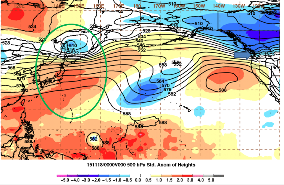
A low pressure system exits East Asia.
A low pressure system exits East Asia. Note the direction of flow into the Pacific Northwest.
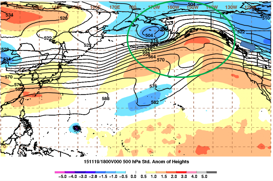
The low pressure system from Eastern Asia moves into Alaska.
The low pressure system from Eastern Asia moves into Alaska. Note the slight northwest flow in Western Canada.
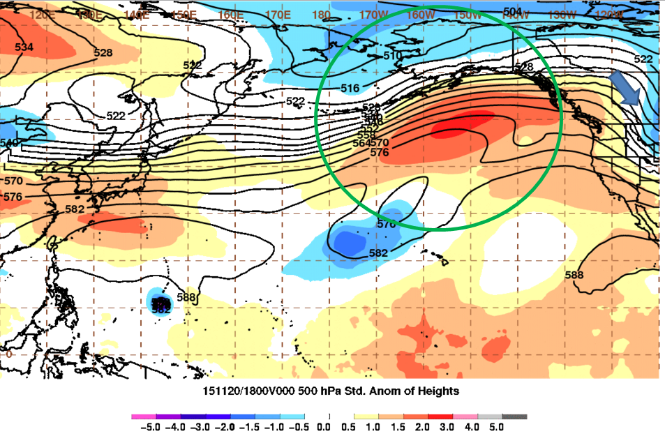
High pressure develops south of Alaska.
High pressure develops south of Alaska. Note the north-northwest orientation of the flow in Western Canada.

But it all started out back in East Asia as an area of low pressure exited there with a strong area of high pressure just south of it. It then moved toward Western Alaska, still with the high pressure area just to its south. Then the high pressure area was able to intensify just south of Alaska and this was able to help change the previously horizontal flow in the Eastern Pacific to become wavier or meridional, which helps storm development. This is indicated in an index called the Eastern Pacific Oscillation that basically identifies the high or low pressure departures from normal with a negative index meaning a high pressure area near Alaska and a low pressure area for a positive index. This index dropped from very positive to slightly negative indicating a change to a higher pressure in that area and a more meridional flow. As a result, a stronger northwest jet developed in Western Canada helping the energetic disturbance dive further south from Canada to just east of the Rockies.


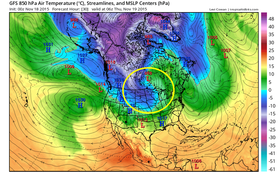
Another part of the equation was getting the cold air into the Northern Plains in the first place and developing an area for the storm to develop at all. This was a put together as the low pressure system that developed starting last Monday and intensified through Thursday sent cold air rushing into the Plains allowing the energetic disturbance from before to dive south in already colder air.

Area encircled by yellow shows the colder (cool colors) flowing into the Northern Plains from Canada on the back end of the low pressure system in Central Canada.
Area encircled by yellow shows the colder air (cool colors) flowing into the Northern Plains from Canada on the back end of a low pressure system in Central Canada’s cold front.


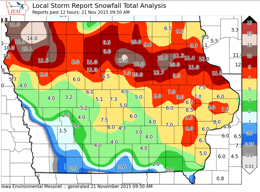
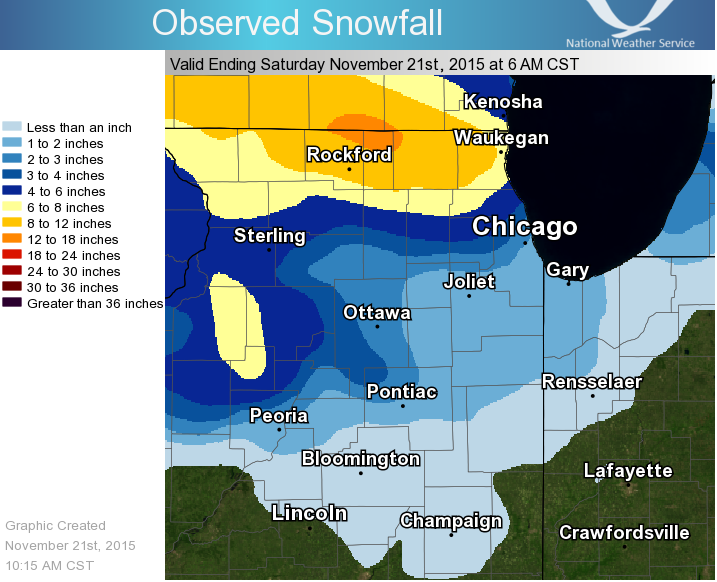
This storm is the first snow storm of the winte, dropping plenty of snow from Iowa into the Great Lakes. As of Saturday morning, some areas saw over a foot of snow with snow continuing in Illinois and moving into Michigan. As the storm continues to move into Michigan, it will develop a negative tilt, which allows it to grab warm, moist air and, within cold air, turn it into snow easier. Snow accumulations are forecast to total 5 to 10 inches, but there could be more than that where the instability is the strongest and if it resides in one area for longer periods of time.  Furthermore, where the winds are blowing in from the right direction, additional snow could be had as lake effect snow forms, especially as the ground surface is able to warm after the storm and cooling winds stay around.

Snow totals in Iowa up to Saturday morning.
Snow totals in Northern Illinois up to Saturday morning.


In addition to the snow, strong winds are also forecast along and near the Great Lakes where the water allows for less friction and strong winds. For example, in Western New York, winds will be from 20 to 40 miles per hour and may gust to 50 or 60 miles per hour from this evening into the overnight. With winds this strong, power outages cannot be ruled out.

Strong Storm May Produce Severe Weather, Blizzard Conditions, and Lake-Effect Snow

A strong storm system moving out of the West will bring heavy snow to the Rockies, severe weather to the Mississippi Valley, and maybe even some lake-effect snow to parts of the Great Lakes before the week is over.

A developing low pressure area will move across the Rockies and into the Central Plains today. Over the weekend this storm brought beneficial rainfall to California, with snowfall across the higher elevations of the Cascades and Sierra Nevada. Up to an inch of rainfall fell across the San Francisco Bay area, with locally heavier amounts of 1-2 inches in Santa Clara and Santa Cruz Counties. Farther inland, 1-2 inches of rain was reported across much of the Central Valley. Strong thunderstorms were also reported across the area, with a tornado warning issued Monday evening for the suburbs of Sacramento, though no tornado was ever confirmed to have touched down.  In the Sierra Nevada, as much as 6-12 inches of snow was reported as of Tuesday morning. At the National Weather Service office in Reno, Nevada, four inches was reported in one hour Monday evening.

As the system moves eastward, snow is expected across much of the Intermountain West today into Wednesday. The heaviest snow is expected across the mountains of Utah and Colorado, where 8-16 inches may accumulate. Rain will change over to snow across the western Plains as colder air filters in behind the system. Snowfall totals of 3-5 inches are expected across western portions of Nebraska and Kansas as well as eastern Colorado, including the Denver Metropolitan Area. The snow will be accompanied by northerly winds of 20-40 mph, gusting to 60 mph at times. As a result, blizzard warnings are in effect for much of this region, with high wind warnings for much of the remainder of the Central and Southern Plains.

Watches and Warnings in effect for the Central US as of Midday Tuesday November 10.
Watches and Warnings in effect for the Central US as of Midday Tuesday November 10. Blizzard Warnings are in Red, Winter Storm Warnings are in Pink, Winter Storm Watches in Dark Blue, Winter Weather Advisories are in Purple, High Wind Warnings are in Light Brown, and High Wind Watches in Dark Brown.

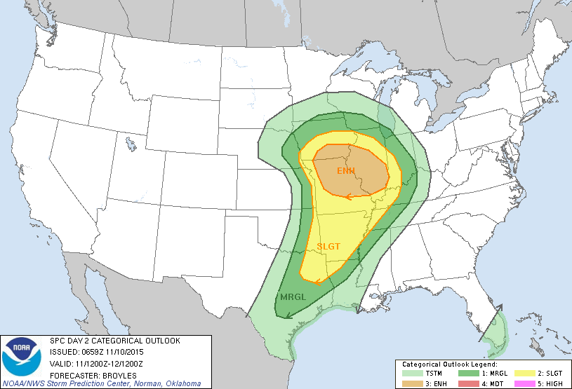
Southerly winds ahead of the storm will continue to draw warm, moist air northward from the Gulf of Mexico. With the clash of airmasses, strong to severe thunderstorms will likely develop ahead of the cold front on Wednesday from northeastern Texas into much of the Mississippi Valley. Strong winds, hail, and tornadoes are the main threats with any storms that do develop. The best chance for tornadoes looks to be across portions of Iowa, Illinois, and Missouri, where a few strong tornadoes are possible.  Just to the north of this area, heavy rain is likely from eastern Nebraska and northern Iowa into southern Minnesota and much of Wisconsin. Rainfall totals of 1-2 inches are possible across this area.

Severe Weather Outlook for Wednesday November 11 from the Storm Prediction Center.

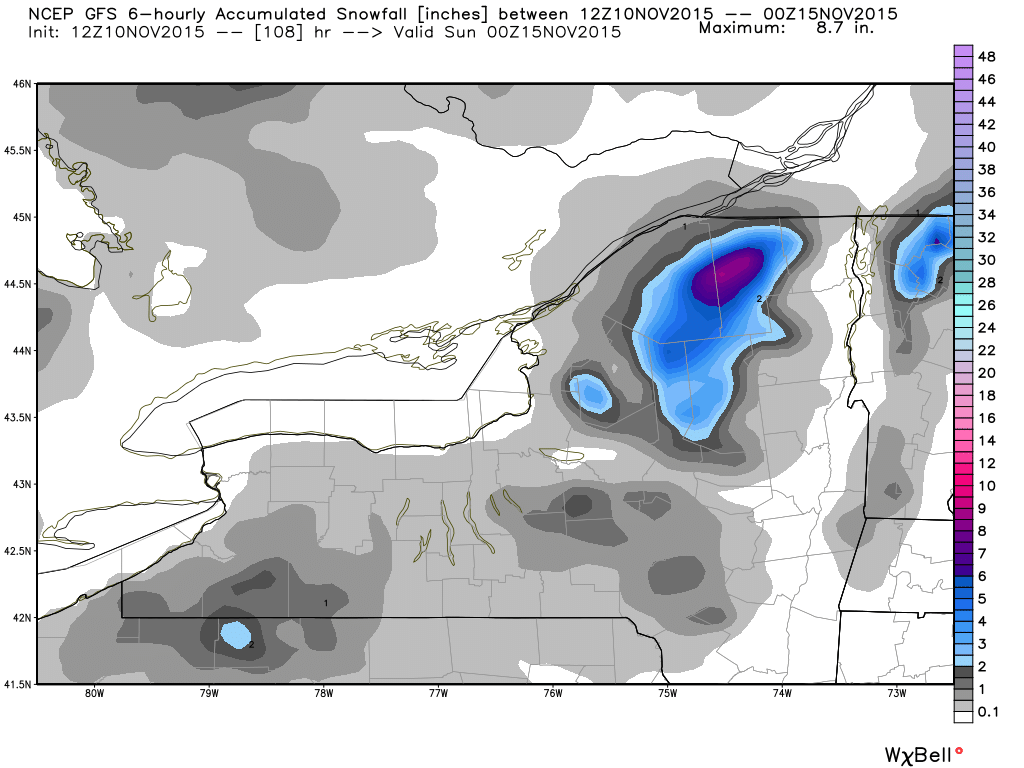
By Thursday, the storm will move into southern Canada, dragging a cold front across the East. This will produce showers across much of the Northeast and Mid-Atlantic states, with gusty westerly winds ushering in cooler air behind the front. As these westerly winds blow over the relatively warmer Great Lakes, some lake-effect rain or snow showers will likely develop on Friday and Saturday. Some snowfall accumulation is possible, mainly over the Tug Hill Plateau of northern New York and parts of the Southern Tier in western New York. A few inches of accumulation are possible, with heavier amounts in the normally favored locations.

Snowfall forecast for Friday and Saturday from the GFS model. Image courtest of WeatherBell.
Snowfall forecast for Friday and Saturday (November 13-14) from the GFS model. Image courtest of WeatherBell.
Back to top