The peak of hurricane season is normally a 6-week period from late August until late September. This year is no exception. We currently have five active tropical systems that we’re tracking, and more may be on the way. Of the five that are currently out there, all of them are a threat to some land areas, four of them to parts of the United States.
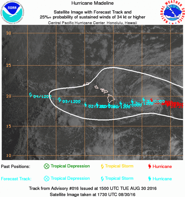
We’ll start in the Central Pacific where Hurricane Madeline is bearing down on parts of the Hawaiian Islands. As of 8am HST Tuesday, Hurricane Madeline was centered about 415 miles east of Hilo, Hawaii, moving towards the west at 10 mph. Maximum sustained winds are near 120 mph, making Madeline a Category 3 Hurricane on the Saffir-Simpson Scale. A Hurricane Watch and Tropical Storm Warning have been issued for the Big Island of Hawaii, and a Tropical Storm Watch has been issued for Maui County, including the islands of Maui, Molokai, and Lanai. The current forecast calls for Madeline to pass just south of the Big Island with some weakening expected. Madeline should pass close enough to Hawaii to bring strong winds and heavy rain to some of the southernmost islands. Rainfall totals of 5-10 inches and locally heavier are possible, especially in the windward sides of the islands. Rough surf will pound most of the islands for the next several days.
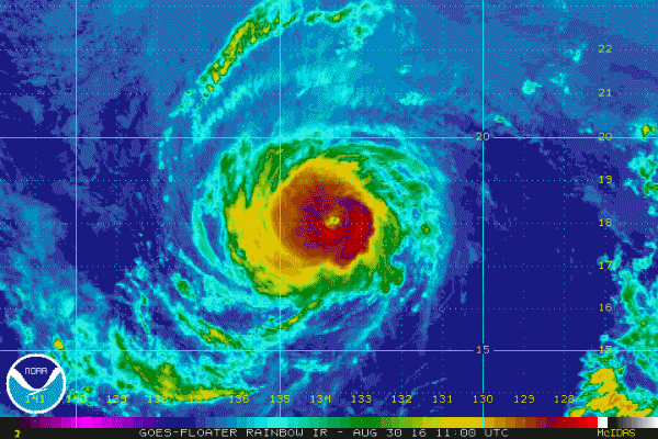
Next up is Hurricane Lester, which was centered about 1350 miles east of Hilo, Hawaii at midday, moving toward the west at 14 mph. Lester has top winds near 120 mph, is expected to steadily weaken over the next few days while continuing in a general westward direction. While Lester is not a threat to land for the next few days, that could change by the end of the week. The current track calls for Lester to gradually turn more towards the west-northwest and northwest by Friday and Saturday, passing a little north of the Hawaiian Islands. While this track would likely spare the islands from most of the wind and rain, if Lester makes that turn a bit later, it would pass a lot closer to the islands. Residents of Hawaii should make sure to keep tabs on Lester’s progress once Madeline moves away from the region.
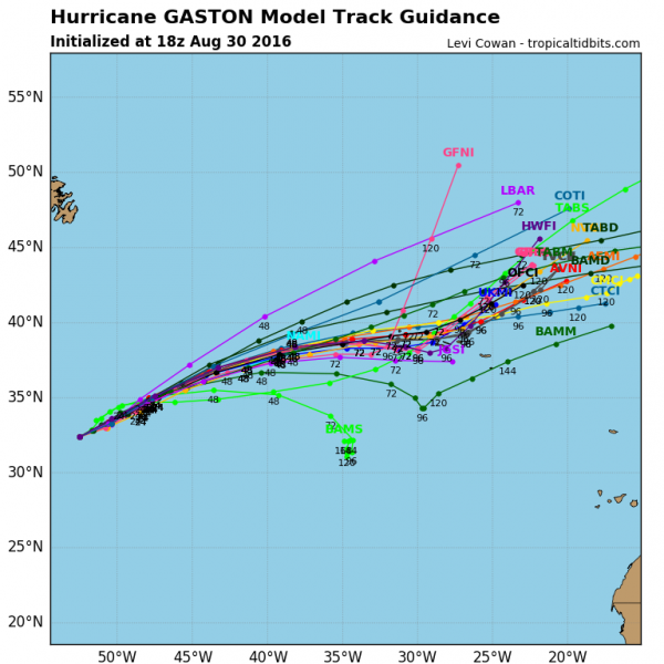
In the Atlantic, Hurricane Gaston is the strongest of the three active storms, but also the one that is farthest from land at the moment. as of midday Tuesday, Gaston was centered about 700 miles east of Bermuda, moving towards the east-northeast at 8 mph. Gaston has maximum sustained winds near 105 mph, but is expected to start to steadily weaken over the next few days. A track towards the east-northeast or northeast is expected to continue for the rest of the weak. On this track, Gaston may move right through the Azores as a weakening hurricane or strong tropical storm towards the end of the week.
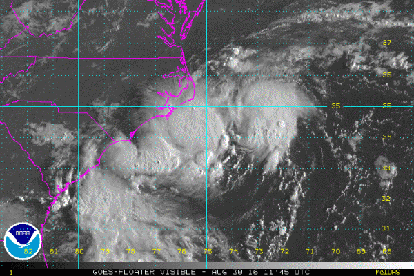
Closer to the mainland we find Tropical Depression Eight. The storm was centered about 70 miles south of Cape Hatteras, North Carolina early Tuesday afternoon and was nearly stationary. Maximum sustained winds are near 35 mph. A slow drift toward the north is expected tonight and Wednesday, with some strengthening possible as the storm moves over the warm waters of the Gulf Stream. A Tropical Storm Warning is in effect for the coast of North Carolina from Cape Lookout to Oregon Inlet. Wins gusts to 30-40 mph and locally heavy rainfall are expected over the Outer Banks of North Carolina tonight and Wednesday. After that, the system should start to head out into the Atlantic and dissipate by later in the week.
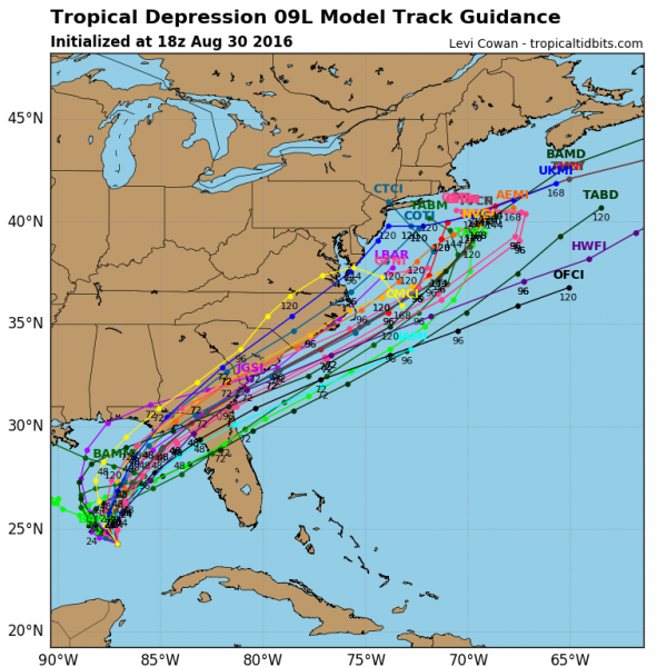
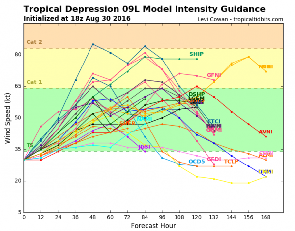
Finally, we get to Tropical Depression Nine, which was centered about 340 miles west of Key West, Florida at midday Tuesday. The storm has maximum sustained winds of 35 mph, and was moving towards the west-northwest at 7 mph. The forecast for this system calls for a turn more towards the north and eventually northeast as an upper-level trough of low pressure starts to steer the system. Strengthening is expected, and the depression could become a tropical storm tonight or early Wednesday. Tropical Storm Watches will likely be issued for parts of the Gulf Coast later today or tonight. Some of the models show the possibility of the storm becoming a hurricane before making landfall along the Florida Gulf Coast later this week. Once it makes landfall, it should quickly cross the Southeast, then emerge into the Atlantic, where some re-strengthening is possible. The system will likely bring heavy rain and gusty winds to parts of the Carolinas, but beyond that its future is uncertain. Some models indicated that it will continue northeastward, out into the Atlantic, while others try to slow it down and head northward up the East Coast in a much-weakened state. Since this could have an adverse impact on the Labor Day Weekend for parts of the East Coast, anyone with interests in that region should keep an eye on the system’s progress.
Finally, a new tropical wave has emerged from the coast of Africa. This wave will cross the Cape Verde Islands tonight, then head westward across the Atlantic. Conditions are favorable for further development, and many of the forecast models show the possibility of this system strengthening over the next several days. It is still at least 5 days away from impacting the eastern Caribbean, so there is plenty of time to monitor its progress before it threatens any land areas.