As spring turns into summer there are mixed signals as to what summer 2017 may bring to the U.S. with respect to temperature and precipitation. Summer for this post is defined as the months of June, July, and August (meteorological summer).
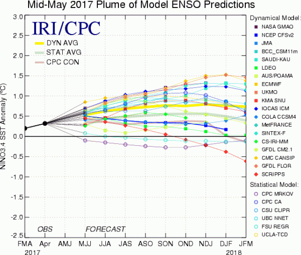
El Nino-Southern Oscillation (ENSO) during the spring season has been categorized as neutral, but forecasts for the summer are for a weak El Nino to begin to evolve. Typically during an El Nino we find temperatures near or a little cooler than normal along with somewhat wetter than normal conditions from the Plains to the East Coast during meteorological summer. To date we are still in neutral ENSO conditions. There is normally a lag time of 60 days or so for the sensible weather to catch up to the ENSO signature. We would not expect a major impact on the summer forecast from ENSO although there may be some contribution, especially since we are currently seeing a weather pattern reflective of El Nino. The chart below from the International Research Institute for Climate and Society (IRI) and the Climate Prediction Center (CPC) shows the most recent forecast for ENSO into next winter. The mean forecast (yellow line) remains under 1.0 which is the classification of El Nino but some models do forecast values over 1.0 later this summer and through the fall.

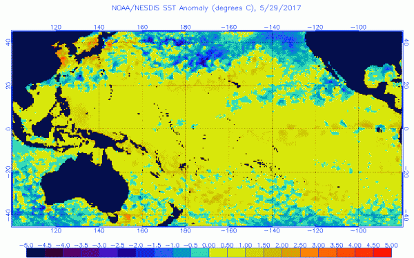
Sea surface temperature anomalies through the tropical Pacific west of South America are a little above normal but not in the classic looking El Nino signature just yet. The sea surface temperature anomalies have increased a bit during recent weeks along the Equator and indicate that the early stages of a weak El Nino could be taking place.

Another indicator we can look at is the Madden-Julian Oscillation or the MJO. The MJO is best described as areas of concentrated thunderstorms through the global tropics that propagate eastward in a 30 to 60 day cycle. These areas of moving thunderstorms influence the weather in the mid latitudes. The MJO forecast through the middle of June implies that the mostly cool, wet pattern we’ve seen during May could continue for the eastern half of the U.S. for at least the next couple of weeks.
Lastly, despite the start of meteorological summer we continue to see signs of high latitude blocking in a fashion to favor episodes of cool, sometimes wet weather for the East. Wet weather may continue to produce flooding and severe weather from the Southern Plains through the Deep South through at least mid June.
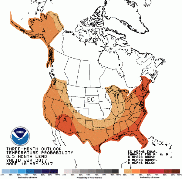
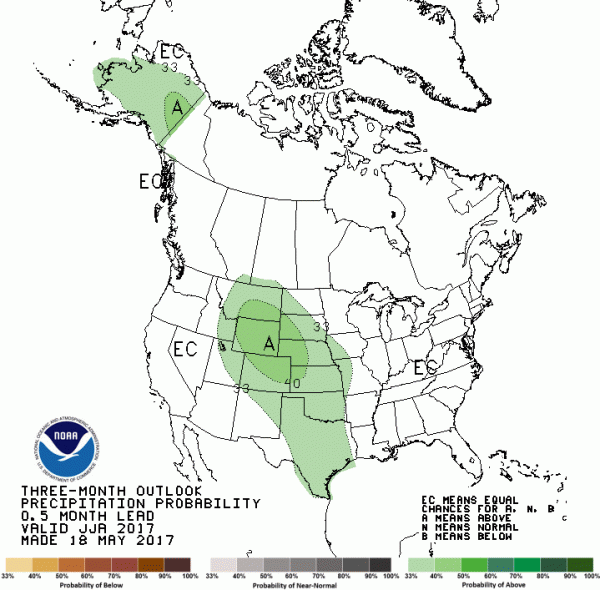
We’ve outlined three indicators that could keep the eastern half of the nation a little cooler and wetter than normal for at least part of the summer. NOAA’s forecast for official summer, (June, July, August) shows a different scenario with warmth for the South and East while cooler and wet conditions cover the interior mountains of the West. It should be noted that some of the most recent modeled forecasts for June produced by NOAA at the end of May do depict cooler than average temperatures for a majority of the nation, including the East and South.


Sea surface temperatures across the western Atlantic and more so through the tropical Atlantic are milder than average as we approach summer’s start. This type of pattern could help elevate temperatures across the eastern and southern U.S. once high latitude blocking and the effects from MJO diminish later in June. It’s possible that the NOAA forecast could have validity to it if one is patient and allows the leftover spring pattern to weaken and fade. Could this be a summer like 1988 which started slow but ended with widespread heat? The South and Plains may be slower to warm with excess soil moisture levels in place but that could add humidity to the equation making for more uncomfortable conditions. There are certainly differing signals for the summer outlook at this time but most of the signs for cooler readings are short term. Once we reach late June and beyond the warmer scenario of NOAA is plausible if El Nino is slow to start and remains weak.